
Depositional Strike..............................................................................................................................................................Direction de dépôt
Direcção de deposição / Dirección de depositación / Richtung von Depositions / 沉积方向 / Простирание залежи / Direzione di deposizione /
Orientation or attitude of the upper limit of slope sediments belt or the strike of sedimentary deposits that are continuous on a slope (deltaic or continental).
See: « Depositional Dip »
&
« Clay Plug »
&
« Continental Slope »
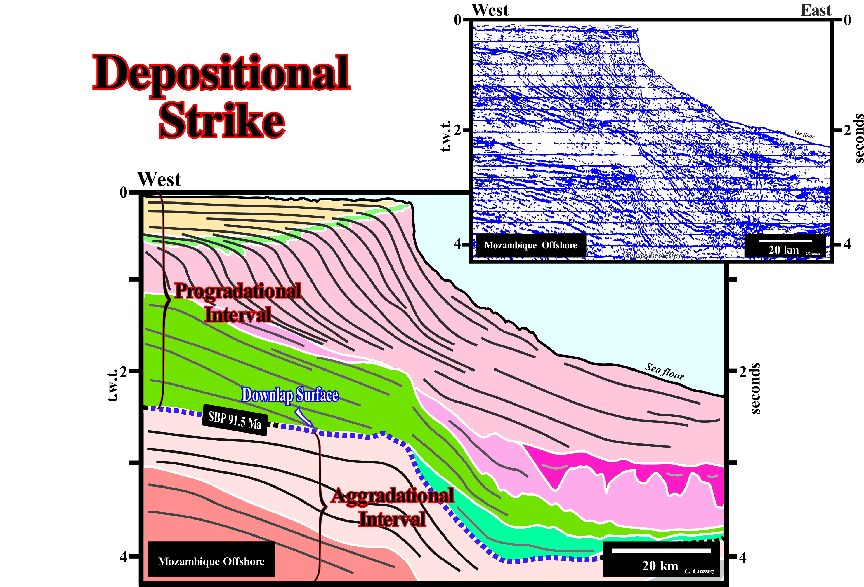
First of all, it is important not to forget the lateral variation of the water-depth of offshore seismic lines, in particular, when the limit between the continental shelf (<200 meters of water-depth) and the continental slope is very abrupt, as it is the case in the auto-trace illustrated in this figure. Seaward of the basin edge, which in this particular case coincides, practically, with the continental edge (but not with the shoreline, since the basin has a platform* or shelf), the seismic-waves have to cross a greater water interval before reaching the sea floor. In this way, they are delayed in relation to the seismic-waves that cross a much smaller water interval (landward of the continental edge). The speed of the seismic-waves in the water is lower than the speed that they have when crossing the sediments. The propagation velocity of the seismic waves varies with the medium in which they propagate (330 m/s in the air ; 1,450 m/s in the water ; 2,000/4,000 m s in the sedimentary rocks and 5,000 m/s in the granite). All this means that on this Canvas auto-trace, the slope of the sea floor, downstream of the basin edge, is very exaggerated. It is even possible that in a depth version the deep sedimentary intervals dip continentward, i.e., westward. This is the case in most West Africa offshores, particularly, in Angola offshore, where the substrate of the basin plunges continentward as opposed to the water-depth**. On this tentative geological interpretation of a Canvas auto-trace of a regional seismic line of the Mozambique offshore, it is evident, at least locally, the depositional strike is North - South, i.e., more or less, perpendicular to the strike of the seismic line. The dip of the progradations forming the successive continental slopes of the progradational interval, is maximum. The slope of the progradations corresponds to the dip of the sediments, which is orthogonal to the direction of the depositional surface. In relation to the progradational interval, the seismic line is, more or less, parallel to the direction of the terrigeneous influx. Probably, this is also true in the aggradational interval, but in this line, such a conjecture is difficult to test. The internal geometry of the reflectors of the aggradational interval is, greatly, deformed by the seismic artefact induced by the rapid and abrupt lateral change of water-depth. All reflectors on the right side of the seismic line are too deep (in time). The velocity of the seismic waves is smaller in the water than in the sediments. Seismic waves took longer to reach the reflecting interfaces. They had to cross the water interval (water-depth). The limit between the aggradational and progradational sedimentary interval corresponds to the main Mesozoic downlap surface (SBP. 91.5 Ma) with which the potential Mesozoic marine source-rocks are, generally, associated. The burial of the source-rocks is, probably, insufficient in the distal part of the seismic line. The organic matter of these source-rocks has no reach maturation. This means the migration of hydrocarbons (if there was generation) is, probably, eastward and not westward. Several sedimentary packages (continental encroachment sub-cycles, induced by 2nd order eustatic cycles) may become evident in the progradational interval. Some of these packages were deposited under lowstand geological conditions (sea level lower than the basin edge). In the upper package, which has been deposited in highstand geological conditions, it is, easy, to recognize facies lines (with the same lithology and fauna) intersect the time lines (chronostratigraphic lines which here have a sigmoid geometry).
(*) This case is very interesting. The water-depth of the actual platform is slightly higher than the seismic resolution. This allows to recognize a platform and to differentiate the continental edge from the shoreline. However, if the water-depth were a little smaller, it is evident that most geoscientists would consider the basin had no continental shelf (no shelf). Although the geological conditions are of highstand. All geoscientists know that after thawing of the last glaciation the absolute or eustatic sea level rose about 125 meters. This is much more difficult to recognize along the fossilized chronostratigraphic lines. Taking into account the seismic resolution, when a geoscientist says the basin does not have a shelf, he just wants to say there is no platform with a water-depth higher than the seismic resolution.
(**) This explains in part (the water column has little influence on the maturation of the organic matter of the source-rocks) that the gas zone is near the shoreline (conventional offshore) and not in the deep offshore.
Depositional Surface.............................................................................................................................................................Surface de dépôt
Superfície de deposição / Superficie de depositación / Abscheidungsoberfläche / 沉积表面 / Поверхность осадконакопления / Superficie di deposizione /
Chronostratigraphic surface along which sediments settle. It can be sub-divided into three segments: (i) An upper sub-horizontal segment, which remains, more or less, at sea level ; (ii) A seaward sloping segment and (iii) A subhorizontal segment seaward of the sloping segment. In certain cases, one or both of the subhorizontal segments may not exist, which requires particular depositional conditions. The vast majority of seismic reflectors have a chronostratigraphic value, i.e., they underlie depositional surfaces.
See: « Deposition (clastics) »
&
« Walther's Law »
&
« Depositional Base Level »
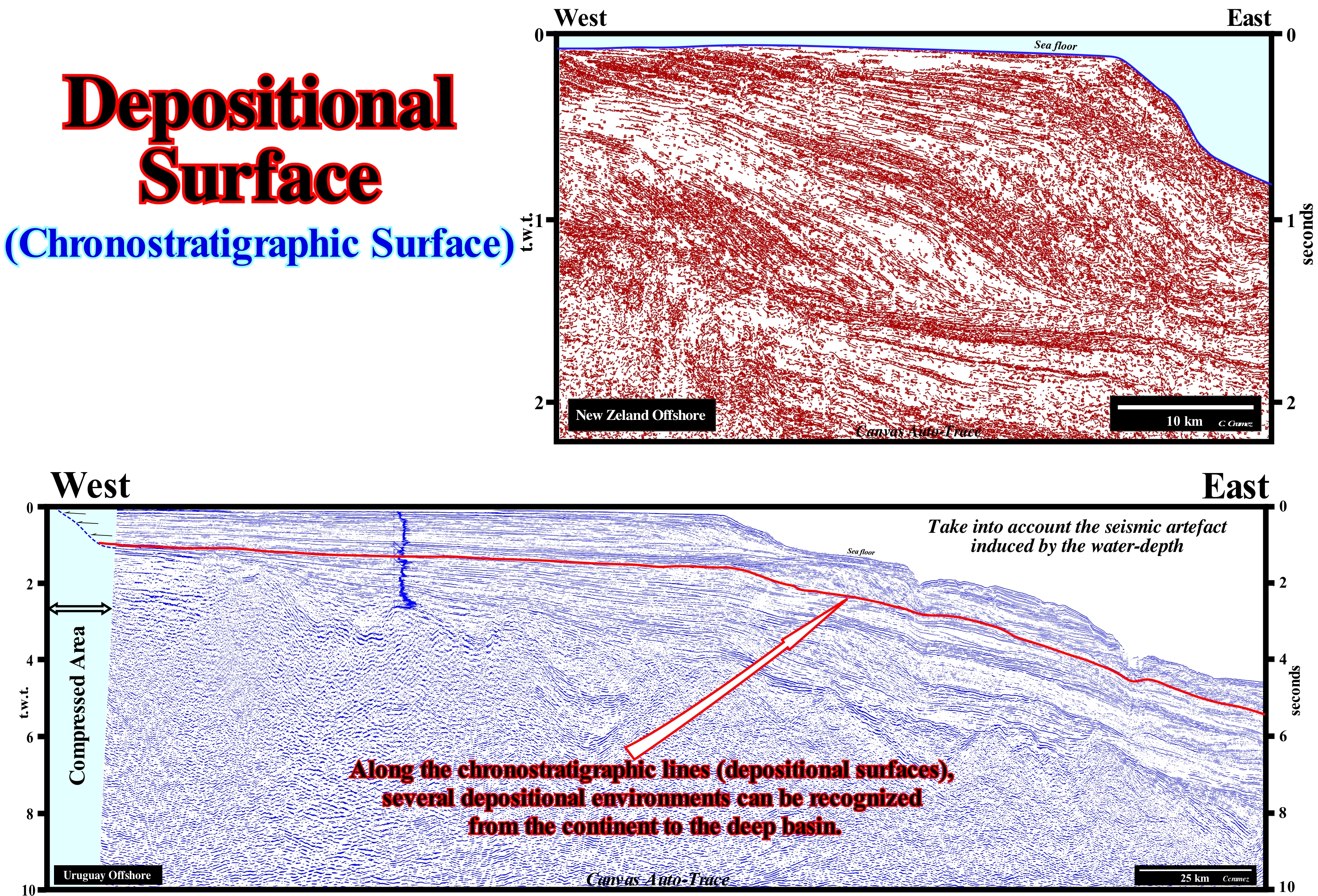
These Canvas auto-traces of a New Zealand (above) and of an Uruguay offshore seismic line (below), despite the recent isostatic uplift, it can be said almost all reflectors correspond, roughly, to chronostratigraphic depositional surfaces. With these auto-traces of seismic lines in time, take into account the seismic artefact induced by the abrupt variations of the water-depth has tendency to degrade the underlying reflectors. A large majority of depositional surfaces have a sigmoid geometry in which three segments can be recognized: (i) A segment dipping seaward, which corresponds, most often, to a continental slope (it is rare to recognize, on seismic lines, a delta slope taking into account the average thickness of a delta and the seismic resolution) ; (ii) A horizontal or subhorizontal segment (at the time of deposition), landward of the inclined segment and (iii) A horizontal or sub-horizontal segment (at the time of deposition) seaward of the inclined segment. The upper slope rupture of the inclined segment emphasizes either the basin edge (when the basin has a shelf) or the continental edge (when the basin has no shelf). Theoretically, along a depositional surface (chronostratigraphic line on the seismic lines) several slope breaks can be recognized. From the continent to the deep-water , we can observe: (i) Alluvial Break or Bayline, which separates the alluvial deposits, upstream, of the coastal plain deposits ; (ii) Depositional Coastal Break (corresponds, more or less, to the shoreline), which separates the coastal deposits from the marine deposits (this rupture may coincide with the basin edge when the basin has no shelf) of the coastal wedge ; (iii) Platform Break, which separates shallow-water sediments from sediments from the continental slope (may or may not coincide with the basin edge or continental edge) and (iv) Basal Break of the Continental Slope, which limit the turbidite deposits and the abyssal plain. The concept of a bay-line, with which not all geoscientists agree, was introduced by Posamentier and Vail (1988), who think that the delta deposition occurs when a water-course finds a water-body, almost immobile, and its velocity decreases almost instantaneously: (i) The coastal plain is formed by sea floor progradations rather than by exhumation ; (ii) The sediments that accumulate in the coastal plain during the progradation of the shoreline form the coastal wedge, which includes river and shallow-water deposits ; (iii) The coastal wedge or coastal prism, whose geometry is wedge-shaped, extends continentward by onlapping over the pre-existing topography ; (iv) The landward limit of the coastal wedge is the bayline, which may move upstream, when the progradation of the shoreline is accompanied by aggradation ; (v) The bayline is the limit between the coastal plain and the alluvial plain ; (vi) Upstream of the bayline, relative sea level changes have no influence on depositional systems. With exception of continental sediments, whose deposition is independent of changes of the relative sea level (local sea level referenced to any fixed point on the Earth's surface, which can bes the base of the sediments or the sea floor and which is the result of combined action of tectonics and the absolute or eustatic sea level, which is supposed to be global and referenced to the Earth's centre), almost all other deposits require the creation or an increase of the available space for the sediments (accommodation, particularly shelfal accommodation). At the level of a sequence-cycle, to form a depositional surface, particularly, landward of the continental edge, which can be the basin edge, a marine ingression is necessary to displaces the shoreline continentward creating shelfal accommodation. The deposition occurs, during the stability period of relative sea level occurring after a marine ingression as the shoreline moves seaward. In other words, the sediments to settle on a depositional surface, the shoreline has to move seaward (after having moved, before, continentward).
Depositional Surface (Depositional base level)...............................................................Niveau de base de dépôt
Superfície de base de deposição / Nivel de base Deposicional / Ablagerungsbasisniveau / 沉积基准面 / Осадочный базис эрозии / Livello di base deposizionale /
Surface on which sediments settle or are eroded. It is a dynamic surface controlled by erosion, deposition, tectonics and eustasy.
See:« Deposition (clastics) »
&
« Sea Floor »
&
« Wave Action Level »

A basal surface of deposition or base level (or erosional base level) is considered to be the equivalent of the relative sea level*, but in certain cases it may be considered as the surface of the water of a lake or the equilibrium surface of fluvial systems. In other words, the depositional base surface or simply depositional surface, as certain geoscientists say, is controlled by the combination of the absolute or eustatic sea level and tectonic movements (subsidence, when the predominant tectonic regime is in extensional or uplift of the sea floor, when the predominant tectonic regime is compressional). In a more practical way, one can say the base level or erosional base level is the altimeter line below which a river can no longer erode and therefore deposition predominates. The base level can be given in relation to the open sea, in the case of rivers that flow there or in relation to the lake. The base level changes along with the relative sea level: (i) A marine ingression rises to the base level ; (ii) A marine regression falls the base level. In the first case, the area of deposition increases. In the second, it is the area subject to erosion, which increases. In continental siliciclastic platforms, it is the basal level of deposition, which determines the equilibrium profile, which represents a compromise between the terrigeneous influx and the water movement (ripples, tides, coastal currents, etc.). However, Posamentier and Vail (1988) conjecture that: (i) Delta deposition occurs when a stream of water encounters a water-body, almost immobile, and its velocity decreases almost instantaneously ; (ii) The coastal plain is formed by progradational processes of seafloor rather than exhumation ; (iii) The sediments that accumulate on the coastal plain during the progradation of the coast line are part of the "coastal wedge", which includes fluvial and shallow-water deposits ; (iv) The coastal wedge, as its name suggests, has wedge-shaped extends continentward by onlapping on the pre-existing topography ; (v) The upstream limit of the of the coastal wedge is the bay-line ; (vi) The bayline may move upstream, when the progradational of the shoreline is accompanied by aggradation ; (vii) The bay-line is the limit between the coastal plain and the alluvial plain ; (viii) Upstream of the bayline, relative sea level changes have no influence on depositional systems. However, certain geoscientists, such as A. D. Miall (University of Toronto) consider the delta deposition occurs at the mouth of a water-course, which means that at the head or apex of the deltas, and not at the bay-line, as admitted by Posamentier and Vail. Therefore, when discussing the provisional equilibrium profile of a river, it should always be said whether the profile considered is in relation to the bayline (Vail position) or to the shoreline (Miall position). Either way, the provisional equilibrium profile of a platform is a dynamic equilibrium surface, somewhat different from the old concept of marine equilibrium profile, in which wave action is the main parameter. In an environment dominated by clastics, the system of dispersion of the platform (waves, tides, etc.) produces texture and facies variations, that move the deposition centre more downstream where the gravitational processes are preponderant. The final result of the equilibrium between sediments and the movement of water on a platform, but also in a lake or even in a river, can be interpreted in terms of hydraulic competence (water capacity to transport sediments according to grain size) and not in terms of quantity. The hydraulic capacity can be measured by the diameter of the larger particles that the water carries. Water energy depends on the energy of waves, storms, tides and currents induced by them, and the mechanisms of dispersal depend on the episodic nature of basal transport across the platform during short periods of intense movement followed by long periods of calm.
(*) Sea level can be of two types: (i) Relative, which is the local sea level, referenced to any fixed point on the Earth's surface, whether it is the base of the sediments or the sea floor, and (ii ) Absolute or eustatic sea level, which is the sea level, global, referenced to the Earth's centre. The relative sea level is the result of the combined action of absolute (eustatic) sea level and tectonics (subsidence or uplift of the sea floor). The absolute sea level is the result of the combination of: i) Tectono-Eustasy that is controlled by the volume variation of the ocean basins in association with oceanic expansion following the rupture of the supercontinents ; (ii) Glacio-Eustasy, which is controlled by the volume of water in the oceans as a function of the amount of ice (assuming that the amount of water in all its forms is constant since the formation of the Earth, about 4.5 Ga) ; (iii) Geoidal-Eustasy which is controlled by the distribution of ocean water caused by variations in the Earth’s gravity field (where gravity is stronger than normal, sea level is thrown to the Earth's centre) and (iv) Steric sea level rise or thermal expansion of the oceans, which is controlled by rising ocean temperatures (if the temperature increases, the water density decreases and, for a constant mass, the volume increases).
Depositional System.............................................................................................................................................................Système de dépôt
Sistema de deposição / Sistema de depositación / Ablagerungssystem / 沉积体系 / Система осадконакопления / Sistema deposizionale /
Three-dimensional set of lithologies, genetically, linked by processes and active (modern) or inferred (old) sedimentary environments. A lateral chain of contemporary depositional systems forming a depositional systems tract or, simply, a systems tract. Depositional systems are used to subdivide, correlate and map rocks.
See: « Sedimentary Environment »
&
« Sequence-Cycle »
&
« Deposition (clastics) »
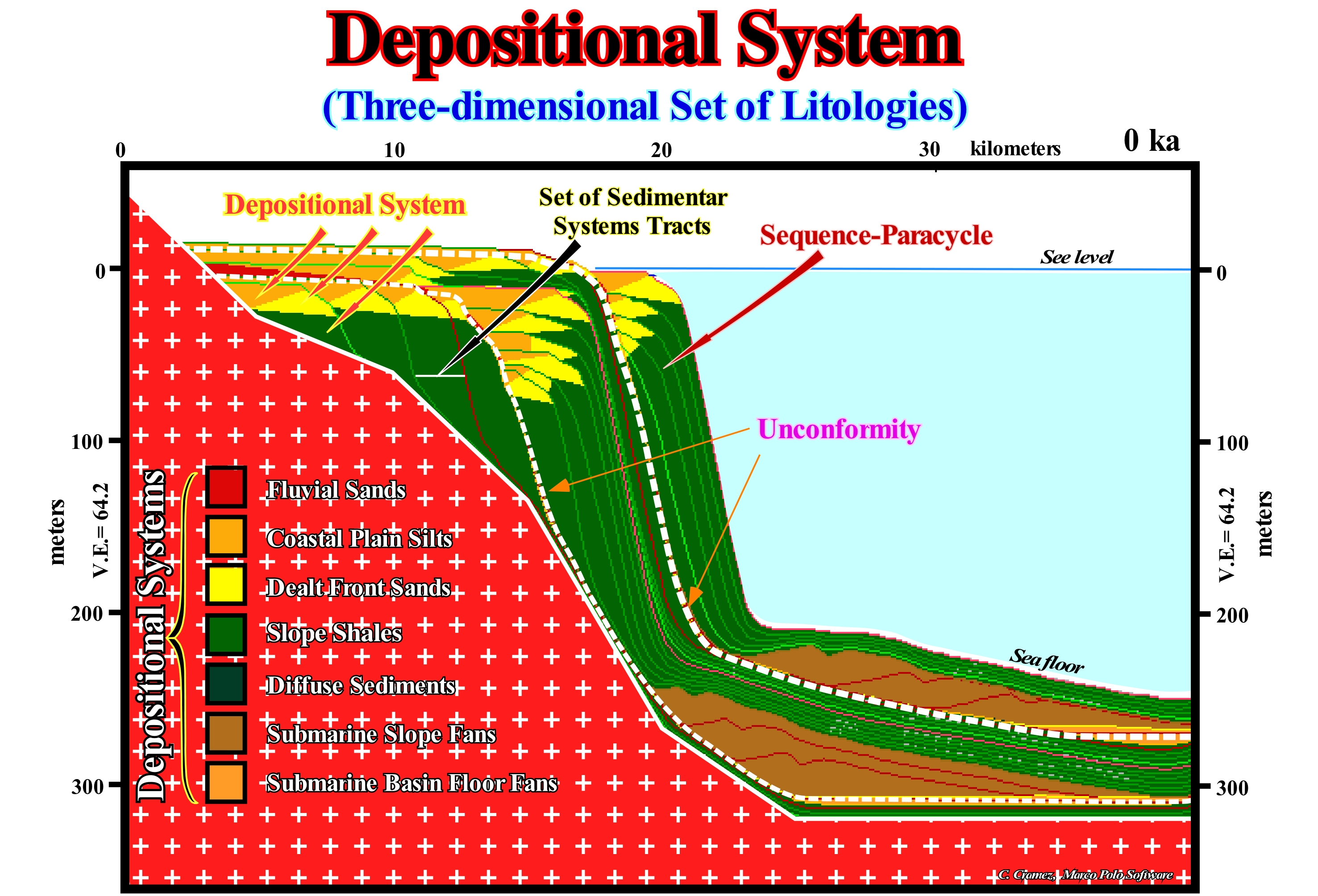
In this sketch, constructed with the Marco Polo software, three stratigraphic cycles said sequence-cycles separated by unconformities (erosional surfaces), which are induced by significant falls of the relative sea level that put the sea level lower than the basin edge. The relative sea level is a local sea level, referenced to any fixed point of the land surface which may be the base of sediments (top of the continental crust) or the sea floor. It is the result of the combination action of the tectonics (subsidence or uplift of the sea floor) and the absolute (eustatic) sea level, which is the global sea level referenced to the Earth's centre. Each of these sequence-cycles was induced by a 3 rd order eustatic cycle, which is characterized by a time-duration of 3/5 My and limited between two consecutive relative sea level falls. Therefore, the difference in age between the two unconformities that limit the sequence-cycle can not be greater than 3/5 My (millions of years). Of these three sequence-cycles, only the intermediate sequence-cycle is complete. A complete cycle-sequence is composed of two groups of sedimentary systems tracts (lateral associations of synchronous and genetically associated depositional systems, i.e., if one depositional system does not deposit, the others, in general, also, do not deposit): a) Lowstand systems tracts group (LSTG) and b) Highstand systems tracts group (HSTG). In the lowstand systems tracts group (LSTG) there are three sub-groups: (i) Submarine Basin Floor Fans (SBFF) ; (ii) Submarine Slope Fans (SSF) and (iii) Lowstand Prograding Wedge (LPW). In the highstand systems tracts group (HSTG), there are two sub-groups: (iv) Transgressive interval (TI) and (v) Highstand Prograding Wedge (HPW). Each of these subgroups of sedimentary systems tracts consists of one or more overlapping sedimentary systems tracts (particularly on the seismic lines), which deposit, usually, during the stability period of relative sea level, that occurs after each relative sea level rise (marine ingression). Each sedimentary systems tract is formed by a lateral association of depositional systems (lithology and fauna deposited in a determined sedimentary environment), genetically, associated. In other words, the sequence-paracycles are deposited between two consecutive eustatic paracycles, among which there is no relative sea level fall, but a stability relative sea level. During an eustatic paracycle (marine ingression increment), the shoreline moves continentward. The coastal plain is flooded, creating or increasing the available space for the sediment (accommodation, particularly, shelfal accommodation). This means that during an eustatic cycle there is no deposition. On the contrary, in the case of flooding of the coastal plain, there is development of a ravinment surface on the preexisting topography. During the stability period of the relative sea level between two eustatic paracycles, one or more sedimentary depositional systems are deposited, whose geometry is always progradational, since the great majority of the terrigeneous influx comes from the continent. In classical depositional systems, the typical sedimentary systems tract is a delta, which corresponds to a lateral and synchronous association, in generally, of four depositional systems, which from the continent seaward, are: (a) Delta plain silts and sands ; (b) Delta fronts sands ; (c) Prodelta shales and (d) Deep shales and, sometimes, turbidites (proximal turbidites). These depositional systems form three types of delta beds (upper, dipping and lower). The upper layers or top-set beds have a sub-horizontal geometry. They form the delta plain and delta front sediments. The dipping seaward layers or foreset beds correspond to prodelta sediments, whereas the lower layers or bottom-set beds, which are, more or less, sub-horizontal are formed by prodelta basal shales which, sometimes, have turbidite deposits induced by failures of the delta front sands. The delta layers more important are the dipping seaward layers or foreset that are the only ones that exist, always, in any type of delta. Taking into account the seismic resolution, in seismostratigraphy (sequential stratigraphy made on seismic lines), as well as, in the geological model shown here, rarely, a sequence-paracycle is constituted by a single sedimentary systems tract.
(*) A relative sea level rise (marine ingression) is, usually, done in stages, i.e., by increments separated by stability periods of the relative sea level during which the sediments deposit.
Depositional Systems Tract ......................................................................................Cortège de Systèmes de Dépôt
Cortejo de sistemas de depósito / Cortejo de sistemas de depositación / Prozession der Ablagerungssysteme / 游行的沉积系统 / Цикл системы осадконакопления / Processione dei sistemi deposizionali /
One of the many depositional systems tracts forming a sequence-cycle, which consists of an association of coeval and genetically associated depositional systems, i.e., if one does not deposit or the others, also, do not deposit (there are, however, few exceptions). Each depositional system is characterized by a facies (lithology) and an associated fauna. Theoretically, it is equivalent a sequence-paracycle deposited in during an eustatic paracycle (marine ingression).
See: « Sequence-Cycle »
&
" Depositional System "
&
" Facies "
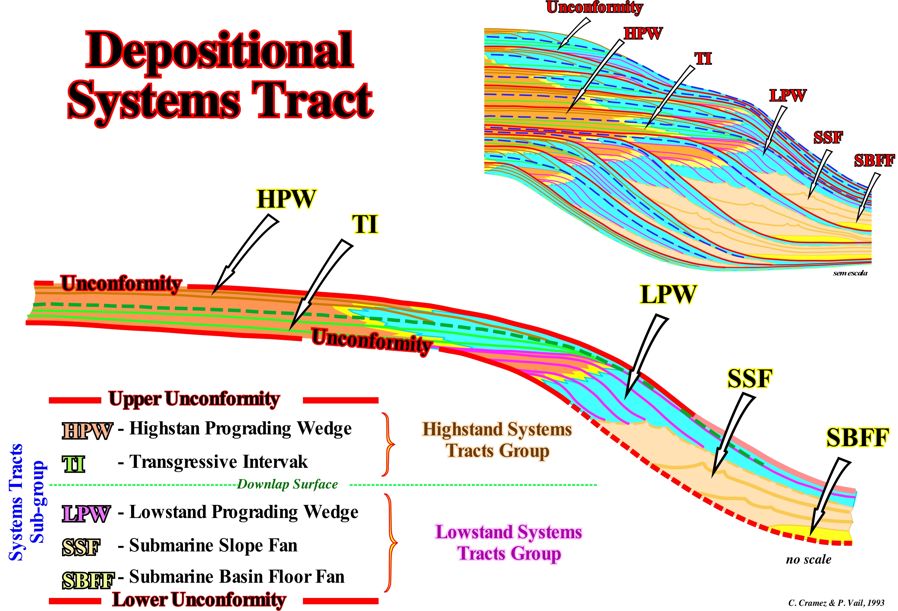
Within a stratigraphic cycle called the sequence-cycle, which is induced by a 3 rd order eustatic cycle, whose duration varies between 0.5 and 3-5 My, there are two large main sedimentary systems tracts group: (i) Highstand Systems Tracts Group (HSTG) and (ii) Lowstand Systems Tracts Group (LSTG). Each of these systems tracts groups is composed of sub-groups as outlined in this figure. A sedimentary systems tract that is a lateral association of depositional systems (characterized by a particular facies, i.e., fauna and environment). Within a sedimentary systems tract, the different depositional systems are synchronous (deposited along a chronostratigraphic line) and genetically associated (if a depositional system does not deposit the others, generally, also do not deposit either), may be formed by one or more sequence-paracycles. In the sketches illustrated in this figure all the sedimentary systems tracts are constituted by various sequence-paracycles, except for the submarine basin floor fans (SBFF). The sedimentary systems subgroups that make up the lowstand systems tracts group of a sequence-cycle, from the bottom up, are: (i) Submarine Basin Floor Fans (SBFF) ; (ii) Submarine Slope Fans (SSF) ; (iii) Lowstand Prograding Wedge (LPW). The systems tracts sub-groups that form the highstand systems tract group of a sequence-cycle are (from bottom to top): (iv) Transgressive Interval (TI) ; (v) Highstand Prograding Wedge (HPW) and sometimes (vi) Bordering Prograding Wedge (BPW), which is not represented in this sketch, since many geoscientists incorporate it in the the highstand prograding wedge (see Descending Sedimentary Systems Tracts). All sedimentary systems tracts sub-groups illustrated in this figure, with the exception of the submarine basin floor fans, are constituted by an overlapping of several sequence-paracycles. The sequence-paracycles (parasequences of the Exxon's geoscientists, particularly at the beginning of Sequential Stratigraphy) are deposited in association with eustatic paracycles, which correspond to a rise of the relative sea level (local sea level referenced to any point of the Earth's surface as the sea floor or the base of the sediment, and which is the result of the combined action of the tectonics and the absolute or eustatic sea level supposed global and referenced to the Earth's centre) without relative sea level falls between them. Between two consecutive eustatic paracycles there are stability periods of relative sea level, during which sediments are deposited, but there are no relative sea level falls. Each sequence-paracycle is formed by one or more synchronous and genetically related depositional systems. For instance, in a lowstand prograding wedge or highstand prograding wedge, sometimes, each sequence-paracycle corresponds to a delta, in which, from the continent seaward, following depositional systems may be recognized : (a) Delta plain silts and sands ; (b) Delta fronts sands ; (c) Prodelta shales and (d) Deep shales and, sometimes, turbidite sands (proximal turbidites). In all sedimentary systems tracts, each sequence-paracycle is deposited in association with an eustatic paracycle, i.e., between each relative sea level rise (marine ingression), which creates available space for the sediments (accommodation), there is, as the term paracycle suggests (from the Greek "para" which means "about", "approximation") any relative sea level fall or, in other words, there is no unconformity between the sequence-paracycles. Each increment of a relative sea level rise creates available space for the sediments, which are deposited, in progradation (displacement of the shoreline seaward), during stability periods of relative sea level that separate the relative sea level rise. In a of depositional systems tract, different facies are genetically associated, so if in a reef depositional system, at given time, an back-reef zone is recognized, the more likely, it is that a front reef and slope reef were also deposited.
(*) Do not forget that contrariwise to what its name suggests a 3 rd order eustatic cycle is not a cycle of absolute or eustatic sea level, but a cycle of the relative sea level, which results from the combination of absolute sea level and tectonics.
(**) A sequence-paracycle is the sedimentary regression that is deposited during the stability period of relative sea level that occurs after a marine ingression (shifting from the shoreline continentward) that it is in acceleration (as during the transgressive interval of a sequence-cycle) or in deceleration (as during highstand or lowstand prograding wedge deposition).
Depth Friction (Surface currents)...................................................................................................................Profondeur de friction
Profundidade de fricção / Profundidad de fricción (movimento de Eckman) / Tiefe Reibung / 摩擦的深度 / Глубина трения / Profondità d’attrito /
Inversion point of the velocity vector. When the wind blows in a certain direction, the surface currents, due to the Coriolis effect, are diverted 45° (rightward in the northern hemisphere and leftward in the southern hemisphere). The velocity vector is, increasingly, diverted, as the depth increases, until it is oriented in the opposite direction to the wind (depth of friction).
See: « Ekman Movement »
Depth Section (Seismic)......................................................................................................................................Coupe profondeur (sismique)
Secção em profundidade / Sección en profundidad (sísmica) / Tiefe Abschnitt / 深度剖面 / Глубинный разрез / Sezioni in profondità (sezioni sismiche) /
Seismic line with a vertical scale in depth and not in time. The vertical scale can be exaggerated or natural (1:1 scale).
See: « Time Section»
&
« Longitudinal Seismic Line »
&
« Geological Section »

An auto-trace of a detail of an old un-migrated) seismic line from the west offshore of Palawan Island (Philippines) is illustrated at the bottom of this figure. It shows where an exploration well was located in 1975. At that time, the vast majority of oil companies still used the anticline theory in petroleum exploration, even if, very often, the drilled structural highs were associated with extensional (lengthening) and non-compressional (shortening) tectonic regimens. Extensional or lengthening structures with a bell-shapes geometry (as anticlines), have, in general, synchronous normal faults at the top of the antiforms, since there is just one way to lengthening the sediments, i.e., by faults normal. In contrast, as sediments can not be shortened and lengthened at the same time, the presence of synchronous normal faults in the top of anticline structures (shortening) is impossible (if they exist, they are either posterior or anterior, but in the latter hypothesis they will be reactivated as reverse faults during the shortening). Geoscientists using seismic lines for the first time (in the beginning of seismic reflection exploration the interpretation of the seismic lines in geological terms was an exclusive realm of geophysicists) did not took care about seismic artefacts (some geologists they did not know even what they were). The vertical scale of a conventional seismic line is in time (the upper auto-trace of the Philippines offshore). Any lateral change of interval velocity, produces in the lower horizons, a pull-down under the seismic interval with little speed. A pull-up is observed under a seismic interval where the seismic waves travel very fast. It is very likely that due to the thickness variation of the water column, which, increases strongly, westward of the well location, the top of the rock-reservoir interval is pull-downed. As the results of the exploration well were, totally, negative. The geoscientists to try to understand such a negative results, migrated the seismic data and made a depth version of the line where the well was located, using the interval velocities found in the electrical logs of the drilled well. The auto-trace illustrated at the bottom of this figure is an auto-trace of a detail of the depth migration version of the same seismic line (offshore of the Philippines). It, strongly, suggests the structural high of the reservoir interval of the un-migrated version, in time, is a seismic artefact. The trap defined on the time version is not structural ("four way dips"), but rather a morphological trap by juxtaposition. It may be said at that time (1975), the geoscientists, including myself, have forgotten that: (i) The Philippines offshore is located within the Mesozoic/Cenozoic megasuture, i.e., in a compressional geological context and (ii) The progressive westward increase of the water-depth produces, in the time version seismic lines, a delay of the seismic waves, which exaggerates the depth of the reflectors. The need to migrate seismic data to better understand the geology of a region has been understood since the early days of seismic petroleum research. The first migrated seismic data dates back to 1921, which means migration algorithms have existed for many years. However, for various reasons, but mainly by economic reasons, it was not until the early 1980s that the migration of the lines became a routine operation. At the top of this figure, two Canvas auto-traces of an Uruguay offshore regional seismic line are shown. On the left, the auto-trace was done on the time version seismic line, whereas on the right, the auto-trace represents the depth-migrated depth version. The influence of the depth-water is more than evident. The substratum of the divergent continental margin does not dips seaward, as many responsible of the petroleum exploration think, but on opposite direction, i.e., continentward. In this precise case, it is obvious that the horizon interpreted as Moho, on the depth version, sharply dips continentward, which is less clear for the sediments at the base of the margin. In any case, considering that the migration of the generated hydrocarbons in this offshore (if there was a generation) is done from East to West, i.e., in the opposition to the dip of the bedding planes, seems to me a small madness knowing the price of an exploration well in this area must surpass, largely, 100 millions USA dollars. It may be said depth version of the seismic lines of many divergent continental margins offshores shown the vast majority of substratum dip continentward rather than seaward, as apparently suggested by time versions.
Desert..............................................................................................................................................................................................................................................................Désert
Deserto / Desierto / Wüste / 沙漠 / Пустыня / Deserto /
Region with an annual rainfall of less than 250 mm. Deserts make up about a third of the Earth's surface. The daily summer temperature may exceed 45° C and the winter night temperature may be less than 0° C. These differences in temperature are, largely, due to the extremely low degree of humidity that deserts have.
See: « Depositional Environment »
&
« Deflation Basin »
&
« Dune »

Most of the desert classifications are based on a combination of the number of rainy days per year, annual rainfall, temperature, humidity, and other factors. Deserts are also classified by their geographic location and by the predominant climate pattern: (i) Deserts in trade winds regions, such as the Sahara desert ; (ii) Deserts in medium latitudes regions, such as the desert of Soonora in North America ; (iii) Deserts due to barriers to moist air, such as the Judean desert, in Israel, or the Death Valley desert in the United States ; (iv) Coastal deserts, such as the Atacama, in Chile, or the Namib Desert, in the SO of Africa ; (v) Monsoon deserts, such as the Rajasthani desert, in India, or the Thar desert, in Pakistan ; (vi) Polar deserts, such as the Antarctic and Greenland desert ; (vii) Fossil deserts or paleo-deserts, that is to say, former desert areas currently present in non-arid regions such as the Kalahari Desert in Southern Africa (Angola, Botswana, Namibia and South Africa) and Sand Hills, in Nebraska (USA). This photograph illustrates the Namibe Desert (Moçamedes desert before 1985) located in southwester Angola near the border with Namibia. The Namibe Desert is a coastal desert. The arid climate of the region is caused by the current of dry air cooled by the cold current of Benguela (marine current that flows northward along the west coast of South Africa, Namibia and Angola until it mixes with the hot current of the south of the equator). This upwelling current is reinforced by the prevailing winds blowing from the desert to the ocean. Winds (from East to West) exaggerate the shifting (to the left) of the shallow waters of the African coast's ocean caused by the Coriolis effect, leaving room for deep and cold waters to rise to the surface. The Benguela current has a width varying between 3 and 300 km and widens as it flows north and north-west. The sand dunes of the Namibe desert, illustrated in this figure, are among the highest in the world. They can reach a height of 400 meters. Rainfall is extremely low and, in certain areas of the desert, it does not reach 30 mm per year. The geometry of the dunes clearly shows that the flanks of windward (which the wind blows), which are much steeper than the leeward flanks (where the wind blows), are oriented towards East, where the sand is pushed by wind to the top of the dune. The Namibe Desert is the country of Welwistschia Mirabilis, which is an extraordinary plant (similar to a giant octopus). It can measure between 2 and 4 meters. This plant was discovered by Dr. Friedrich Welwisch in 1860. Charles Darwin (1809-1882) named it "platypus of the plant kingdom" and considered it miracle of evolution. Only with the morning mist, each specimen can live about 2,000 years. Due of its strange shape (with only two rigid, fibrous leaves attached to a thick, flat stem), biologists consider Welwistschia Mirabilis as a kind of dwarf tree.
Desiccation........................................................................................................................................................................................................................Dessication
Dessecação / Desecación / Austrocknung / 干燥 / Высушивание / Essiccazione /
Excessive moisture loss or drying process of a rock, sediment or any other material. It is a dehydration to eliminate as much water as possible. Desiccation may be natural or forced.
See: « Sediment »
&
« Compaction "
&
« Hydrosphere "
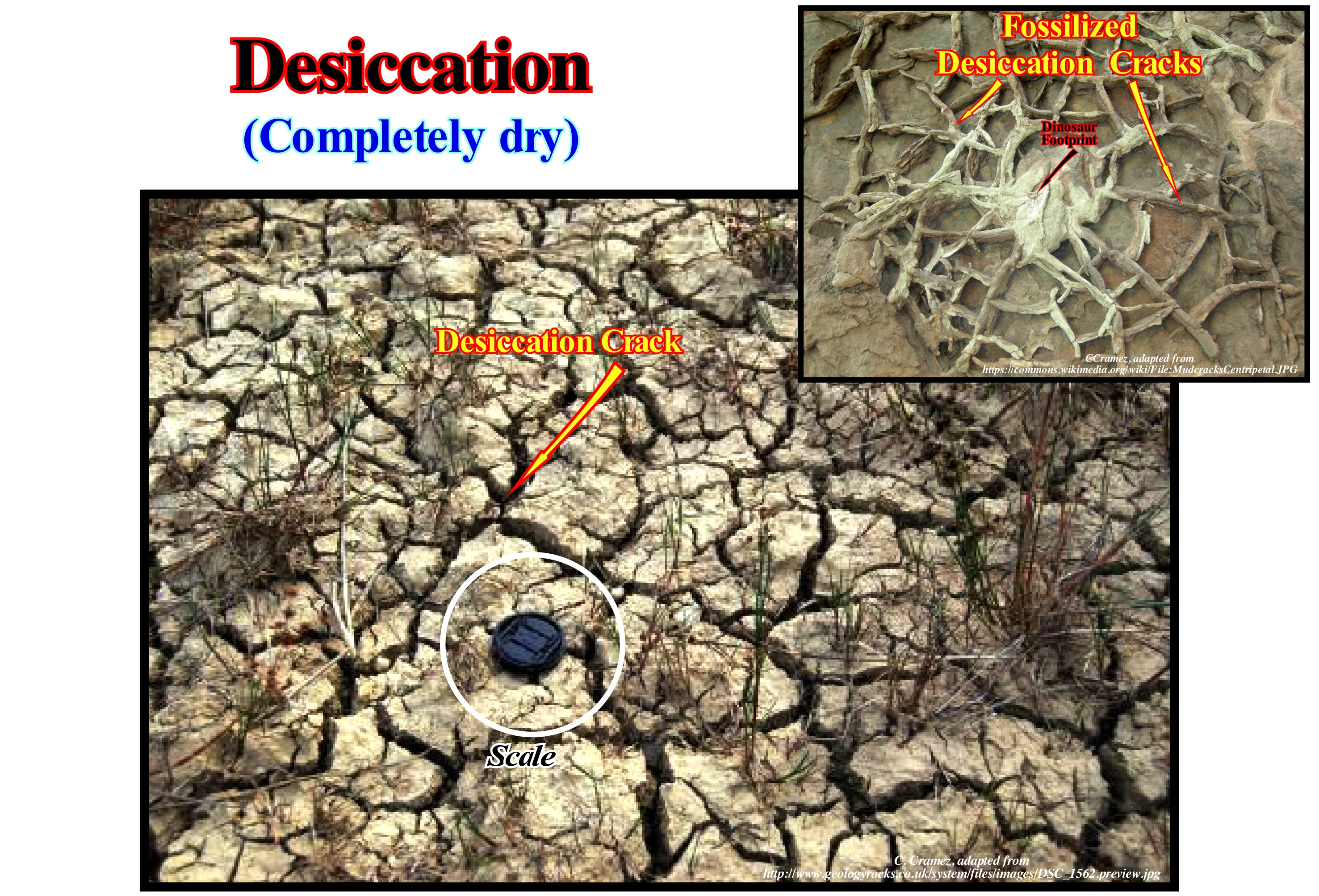
As shown in this figure, in shaly deposits, due to the fact that the desiccation is faster at surface than in depth, desiccation cracks are formed which are arranged in more or less polygonal systems. In civil construction, very rapid desiccation of building materials can, strongly, alter the technical characteristics of such materials, such as, produce a strong decrease in resistance to the application of a load, which, of course, can have a catastrophic consequence. A desiccant is a hygroscopic substance (which has the property of absorbing water) that induces a desiccation or keeps it when the environment around it is more or less closed. The most frequently cited examples of desiccants are: silica gel, calcium sulfate, calcium chloride, montmorillonite clay, diatomaceous clay etc. Certainly, your mother, like mine, always put rice in the salt shaker. Rice is often used in salt shakers to keep cooking salt flowing effectively and preventing lumps from forming. Rice is not a good desiccant because it has a very low adsorption capacity and also because it is susceptible to being attacked by micro-organisms. When used in the salt shaker, salt acts to limit the development of bacteria and mold. Salt itself is another effective desiccant, used for millennia for food preservation, such as red meat (ham) and fish (cod). When a relative sea level fall puts the sea level lower than the platform edge (lowstand geological conditions), the sediments of the former continental shelf (if the basin had a shelf) are exhumed and thus exposed to erosive agents. The sediments begin to desiccate, which will facilitate the action of erosive agents, in particular the action of the wind, due to the formation of desiccation cracks, and the formation of loess*.
(*) Loess is a loose detrital sedimentary rock formed by the accumulation of clay from wind erosion (deflation), particularly, in the desert and periglacial regions.
Destructive Process (Reef)....................................................................................................................Processus destructif (Récif)
Processo Destructivo / Proceso destructivo (arrecife) / Destruktiven Prozess (Riffe) / 破坏过程(礁) / Деструктивный процесс (рифы) / Processo distruttivo (scogliere) /
A process that can destroy or cause damage to the growth of a reef, such as the action of the sea waves and bioerosion (biological destruction).
See : « Reef »
Determinism.......................................................................................................................................................................................................Déterminisme
Determinismo / Determinismo / Determinismus /決定論 / Детерминизм / Determinismo /
Conjecture that an event requires an antecedent event and conditions controlled by the laws of nature. Such conjecture, that is quite old, was analyzed, mathematically, in the seventeenth century. Determinism is, deeply, linked to the understanding and predictions in the physical sciences, as well as, to the action freedom of humans.
See: « Theory of Evolution »
&
« Thermodynamic Laws »
&
« Exponential Growth»
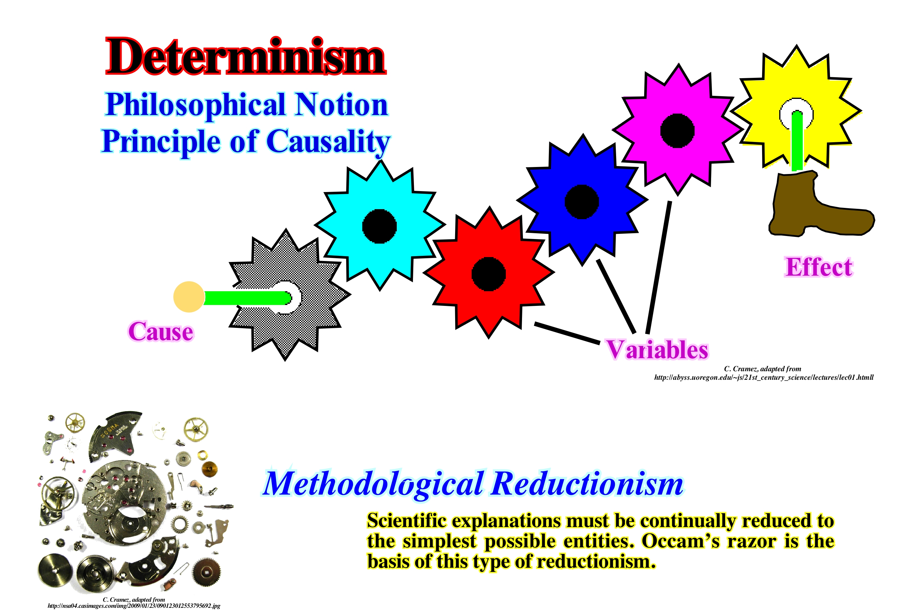
Although in the most vulgar sense determinism refers to a reductionist causality (reduction of all phenomena of the Universe, to mechanics or to chemistry), causality is not necessarily synonymous with reductionism. There are three basic types of determinism: (i) Predeterminism, when it is admitted, as Laplace did, or as in deism* and behaviourism**, that every effect is, already, fully present in the cause ; it is a mechanistic determinism where the determination is placed in the past, in a causal chain, totally, explained by the initial conditions of the Universe ; (ii) Postdeterminism, when, as in teleology, we admit that all causality of the Universe is determined by some purpose ; it is a mechanistic determinism where determination is put in the future by the imagination of some entity outside the causal universe (God) ; (iii) Codeterminism, when we admit, as in chaos theory, the emergence theory or the concept of rhizome (descriptive or epistemological model in the philosophical theory of Gilles Deleuze and Félix Guacari), that not every effect is totally contained in the cause. This means that the effect itself can simultaneously (causally) interact with other effects, and may even entail a different level of reality from the level of previous causes***. It is a determinism where determination is placed in the present or in the simultaneity of processes. Critics of determinism claim noncausality to justify free will and free choice, generally, assigning to determinism a mechanism or fatalism such as in predeterminism and postdeterminism. What above all differentiates the determinism from their critics is the affirmation of the latter that the Soul, Will, Desire, and Choice exist in a separate universe, separated from the causal Universe.
(*) Philosophical belief that posits that God exists as an un-caused First Cause ultimately responsible for the creation of the Universe, but does not interfere directly with the created world.
(**) Either behaviourism is one of the three main currents of psychology, along with the psychology of form ("Gestalt") and analytical psychology (psychoanalysis). Behaviourism is a branch of psychology, which behaves as the object of study.
(***) Interaction at the molecular level forms another level of reality, life. The interaction between individuals forms another level of reality, that is, society.
Deterministic Chaos............................................................................................................................................Chaos déterministique
Caos Determinístico / Caos deterministico / Deterministischen Chaos / 确定性混沌 / Детерминистский хаос / Caos deterministico /
Behaviour of a system, whose dynamics is, totally, dependent on the initial conditions, without random elements involved. The deterministic nature of such a system does not make it predictable. Deterministic chaos or, simply, chaos, is observed in many natural systems. Geoscientists discuss the existence or not of a chaotic dynamics in the lithospheric plate tectonics.
See: « Plate Tectonics Theory »
&
« Systems' Theory »
&
« Weather (state of atmosphere) »
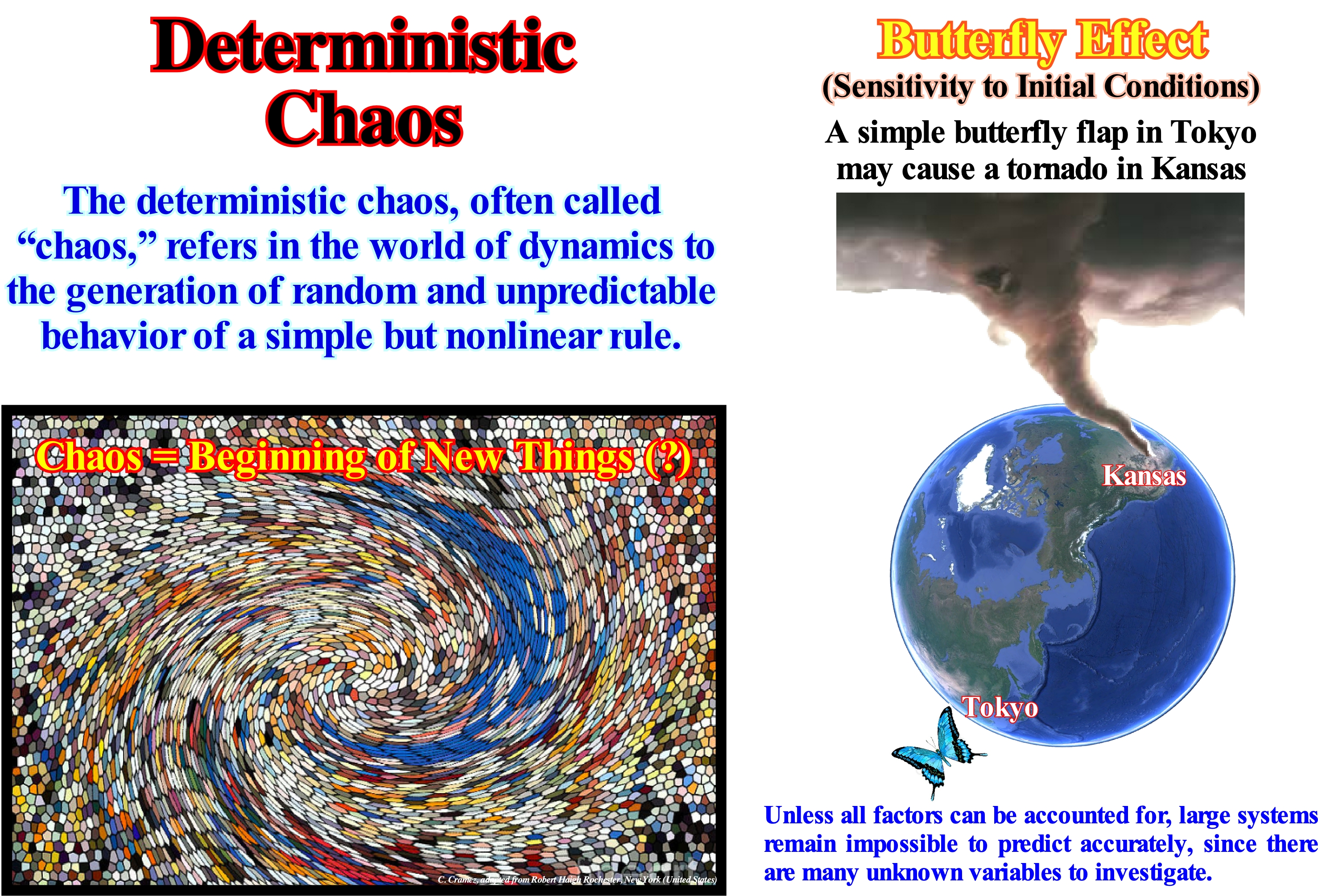
A system* is chaotic if its trajectory through space is dependent on the initial conditions, i.e., if small causes, difficult to observe, can produce great effects. The word chaos was used in Greece to designate an abyss, cliff or emptiness. The philosophers Plato and Anaxagoras and the Stoics used it to designate primordial material, amorphous and formless. Today, the term chaos has, above all, a negative meaning. It means confusion, disorder, etc. In science, chaos was first used in 1975 to designate the sensitivity of certain systems to small changes in the initial conditions. This means the normal behaviour of a system suddenly becomes irregular. K. Lorenz (1903-1989) observed such behaviour in mathematical models used in meteorology (a simple butterfly flap in the Gulf of Mexico influences the climate in Europe). Before Lorenz, H. Poincaré (1854-1912), studying the stability of the orbits of the planets of our solar system, found that the small perturbations of the orbits increased with time. Easier to understand the deterministic chaos (in relation to the solar system) is the behaviour of a double pendulum (the end of the first pendulum is attached another pendulum). When the pendulum is, gently, pushed, each system oscillates regularly. When the thrust is stronger, the pendulum oscillates irregularly and the calculation of its behaviour is not predictable. It enters a state of deterministic chaos. The system has a meteorology, i.e., a state that the system wants to achieve. Today, geoscientists are aware that even the systems studied by classical mechanics can behave in an inherently unpredictable way. Even if such a system can be, perfectly, deterministic, in principle, its behaviour is, completely, unpredictable in practice. It is this phenomenon that has been called deterministic chaos.
(*) Set of interdependent elements in order to form an organized whole. Every system has a general goal to achieve. In a system, all objects are systems or components of another system. An atomic nucleus is a physical material system composed of protons and neutrons related by a strong nuclear interaction metabolic. In the same way, a scientific theory is a logical conceptual system composed of hypotheses, definitions and theorems related by co-referencing and deduction.
Detrital Flow.........................................................................................................................................................................Débit ou Flux détritique
Fluxo ou escoamento detrítico / Flujo detrítico / Detritische Fluss / 碎流 / Обломочный поток / Flusso detritico /
When the fluid has a large amount of thin material in suspension, which serves as support for the transport, in suspension, of some larger particles.
See: « Turbiditic Current »
Detrital Remnant Magnetism (DRM).....................................................Magnétisme Rémanent Détritique
Magnetismo Remanente Detrítico / Magnetismo Remanente Detrítico / Magnetismus Remanent Detritics / 碎屑剩余磁性 / Магнетизм остаточный детрит / Magnetismo Remanent Detritico /
Remaining depositional magnetism (RDM), created when magnetic particles are released from a rock, transported and deposited forming a new new rock, at a temperature below the Curie point*. When deposited they are oriented according to the magnetic field at the moment of the sedimentation, which is about 1000 times weaker than the magnetism of a lava, where each small dipole is, perfectly, aligned with the applied field.
See: « Paleomagneic Stratigraphy »
(*) Temperature above which a ferromagnetic (attracted by a magnet) or piezoelectric material (which can create an electric field) becomes paramagnetic (weakly attracted by an externally applied magnetic field, forming internal, induced magnetic fields in the direction of the applied magnetic field ; in contrast, a diamagnetic material is repelled by magnetic fields and form induced magnetic fields in the direction opposite to that of the applied magnetic field).
Detritivore (Organism)...............................................................................................................................................................Détritivore (Organisme)
Detritivoro / Detritívoro (organismo) / Saprobiont, Detritophages / 腐生营养 / Детритоядный, питающийся отбросами (организм) / Saprofita, Detritivori (organismo) /
Organism that feeds from debris, i.e., a heterotrophic organism that obtains nutrients from detritus (decomposing organic matter). It contributes to the decomposition and recycling of nutrients. Synonym of Saprotroph (saprophagous).
See: « Sediment »
&
« Saprotroph (organism) »
&
« Heterotrophic (organism) »

In biology (a science that studies living beings), detritivorous or necrophagous (scavengers) are animals (multicellular living beings, whose cells form biological tissues, with the capacity to respond to the environment that surrounds them), which feed on organic remains (plants and animals dead), recycling them and returning them to the food chain to be reused by other living organisms. The most common examples of detritivorous are buzzards, vultures, hyenas and various species of beetles and flies. This type of feeding is a form of saprophagous, which in the case of plants is called saprophytic. With the same etymology the term saprophagous or saprotrophs is, also, used for animals. Other general terms for this type of living beings are saprobous or saprobionts. Detritivorous are of fundamental importance. They promote the degradation of organic matter, facilitating the work of fungi and bacteria. In the soil there many microorganisms working in the transformation of nitrogen compounds into forms that can be used by plants. Many are bacteria living in the rhizosphere (zone that includes the surface of the root and the soil that adheres to it). Some of these bacteria (nitrogen-bacteria) can use nitrogen from the air and convert it into useful compounds for plants by a process called nitrogen fixation. The ability of bacteria to degrade a wide variety of organic compounds is very important. There are specialized groups of micro-organisms that work on the mineralization of specific classes of compounds, such as the decomposition of cellulose, which is one of the most abundant constituents of plants. In plants, bacteria can also cause disease. The decomposing bacteria act in the decomposition of the trash, being essential for such task. They can also be used for bioremediation* by acting on the biodegradation of toxic wastes, including hydrocarbon spills. (http://en.wikipedia.org/wiki/ DetritC3%ADvoro and http://en.wikipedia.org/wiki/Bactéria).
(*) Bioremediation is the process by which living organisms such as micro-organisms, fungi, plants, green algae or their enzymes are used to reduce or remove contaminations in the environment. Bioremediation is able to regenerate the original ecosystem equilibrium from biodegradable waste treatment processes.
Detritus, Debris (Geology).............................................................................................................................................................Détritus (Géologie)
Detrito / Detrito (geología) / Schutt, Geröll / 碎片,碎屑 / Детрит, обломки / Detrito /
Sedimentary particle*, fragment (organic) or loose and worn grain resulting from the alteration and erosion of the rocks.
See: « Sediment »
&
« Sedimentation »
&
« Erosion »
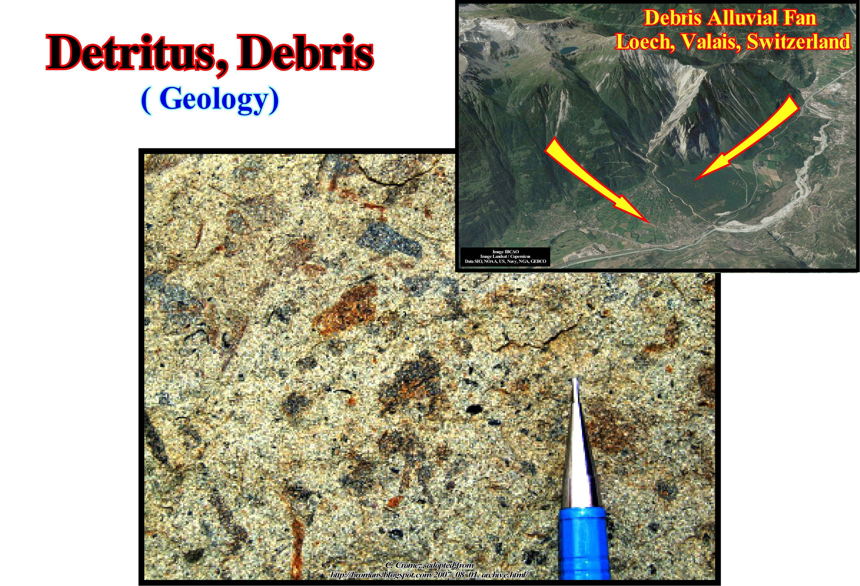
In general, in Geology, the term detritus is used to denote a particle derived from pre-existing rocks by weathering processes (decomposition of rocks, soils and minerals by direct contact with the atmosphere) and erosion (abrasion or displacement of solids, i.e., a sediment, soil, rock and other particle by wind, water or ice due to gravity or living organisms). Debris can be lithic fragments (when preexisting rock is easily recognized) or mono-mineral fragments (mineral grains). These particles are, often, transported by sedimentary processes to deposition systems such as rivers, lakes or oceans, where they settle in, more or less, stratified sediments or sedimentary layers. Then diagenetic processes can transform them into sedimentary rocks by cementation (deposition process of the dissolved minerals in the interstices of the sediments) and lithification (process by which the sediments are compacted under the action of the pressure that expels the fluids between the pores and gradually turns them into solid rock). Later, the sedimentary rocks, in turn, altered, fragmented and eroded form again debris. In this photograph, taken perpendicular to a stratification plane, a series of organic debris is recognized that are integral part of the rock. In the same way, the small black fragments of carbonated clay are easy to recognize. The presence of organic debris, such as coal, is very frequent in turbidite deposits. In fact, organic debris, when associated with other sediments, can give valuable indications about the deposition environment. For instance, if in a given sample, a geoscientist recognizes coal and glauconite debris (authigeneous**), the sample, probably, comes from a turbidite deposition environment. If the sample has coal debris but no glauconite debris, the sample comes, probably, from a non-marine sedimentary environment. If the sample only has glauconite of neoformation, it comes, certainly, from a rock that has deposited in a marine environment and probably of shallow water. This criterion, known by the Selley square name, is used, almost always, by geoscientists who control drilling wells to differentiate deep environments from platform environments.
(*) Sedimentary particles range from the fine dust transported by high-altitude winds to gigantic erratic blocks moved by glaciers. Standard sieve sizes are : (i) Small boulder > 250 mm of diameter ; (ii) Large cobbles between 128 and 256 mm ; (iii) Small cobbles between 128-64 mm ; (iv) Very coarse gravel between 64-32 mm ; (v) Coarse gravel between 32-16 mm ; (vi) Medium gravel between 16-8 mm ; (vii) Fine gravel between 8-2 mm ; (viii) Very fine gravel between 4-2 mm ; (ix) Very coarse sand between 2-1 mm ; (x) Coarse sand between 1-0.5 mm ; (xi) Medium sand between 0.5-0.25 mm ; (xii) Fine sand between 0.25-0.125 mm ; (xiii) Very fine sand between 0.125-0.062 mm ; (xiv) Coarse silt between 0.062-0.031 mm ; (xv) Medium silt between 0.031-0.016 mm ; (xvi) Fine silt between 0.016-0.008 mm ; (xvii) Very fine silt between 0.008-0.004 mm ; (xviii) Coarse clay between 0.004-0.002 mm ; (xix) Medium clay between 0.002-0.001 mm ; (xx) Fine clay between 0.001-0.0005 mm ; (xxi) Very fine clay between <0.0005 mm.
(**) The term authigeneous refers to minerals or rocky materials that have formed "in situ" instead of being transported and deposited. These minerals such as quartz, chlorite, etc. and the cements that fill the pores of the rocks, are formed during diagenesis. Glauconite and evaporite minerals such as halite are also authigeneous minerals or formed in situ.
Deuterogenic (Rock)...........................................................................................................................................................Deuterogénique (Roche)
Deuterogénica / Deuterogénica (roca) / Deuterogenic rock / 后生岩 / Дейтерогенная (порода) / Roccia Deuterogenica, Roccia secondaria /
Rock composed of rock debris or mineral pr-existent. A deuterogenic rock contrasts with a protogenic rock designating an original crystalline or igneous rock. Some geoscientists consider that an element is deuterogenic when it comes from a protogenic rock. They reserve the term deuterogenic to designate elements related to changes in the igneous rocks occurring during the last stages of its consolidation.
See: " Detritus "
&
« Sediment »
&
« Rock Cycle »

Although this term is, mainly, used to designate minerals, it can be said all clastic sedimentary rocks and metamorphic rocks are deuterogenic. In fact, the former are formed when the sedimentary particles are deposited from the air, ice, wind, or streams of water streams that carry the suspended particles. Particles or debris are, generally, formed when weathering and erosion depart from protogeneous or deuterogenic rocks in a given area (source area, feeding area or provenance area) in a loose material. This material is then transported from the source area to the deposition area. The type of debris transported depends on the geology of the sediment source area. Some sedimentary rocks such as evaporites and many carbonate sedimentary rocks are composed of original materials that formed at the deposition site and therefore can not be considered as deuterogenic rocks. This means that the nature of a sedimentary rock depends not only on the origin of sediments, but also on the depositional environment in which it forms. In contrast, other rocks, as shown in this figure, are, typically, deuterogenic, since many of the clasts are fragments of pre-existing rocks, many of which are protogenic (crystalline rocks of igneous origin). The metamorphic rocks are the product of the transformation of any type of rock (protogenic or deuterogenic) that was taken to an environment where the physical conditions (pressure, temperature) are very different from those where it formed rock formed. In these environments, and high pressure and temperature many minerals become unstable and react forming other minerals, which are stable under such conditions.
Devonian.........................................................................................................................................................................................................................................Dévonien
Devónico/ Devónico / Devon (Geologie) / 泥盆纪 / Девонский период / Devoniano /
Geological period from the Paleozoic era, after the Silurian and before the Carboniferous. It lasted between 400 and 345 million years ago. It corresponds to a system of rocks that was first described and studied in the Devonshire region (England).
See: « Geological Time »
&
« Paleozoic »
&
« Chronostratigraphy »

The time boundaries of the different periods of the Paleozoic Era vary according to the geoscientists (Holmes, 1937, Holmes, 1960, Kulp, 1961, Odin et al., 1982, Harland et al. Odin, 1993; Gradstein & Ogg 1996; Laurie et al., 1996; Remane et al., 2000, etc.). In this figure is illustrated the most probable paleogeography during the Devonian as well as a hypothetical landscape of this geologic period. During the Devonian, the seas were dominated by brachiopods and rugged and tabular corals, which built large bioherms or reefs in the shallow seas. The trilobites, still very abundant, began to disappear at the end of Devonian. The first fish appear to have appeared in the Devonian (sarcopterygians) and their diversification has been very rapid. It was during this geological period that the land began to be colonized. Before the Devonian there were no organic accumulations in the soils, which, of course, gave them a predominant red colour. From the beginning of the Devonian, the terrestrial vegetation began to develop. The plants still had no roots or leaves and many of them, too, had no vascular tissues. The plants were probably spread by vegetative growth (growth by cell division without sexual reproduction) and did not grow more than a few centimeters. The first fauna that lived among these plants was mainly arthropods. Near the end of the Devonian, the first plants with roots and leaves appeared and developed very rapidly in such a way that the geoscientists call it the Devonian Explosion. This emergence was rapid and accompanied by a diversification of terrestrial plants and arthropods. At the end of the Devonian, the seedlings appeared. During Devonian, the Paleozoic oceans began to close to form, later, the supercontinent Pangea. Freshwater fish were able to migrate from the continents of the southern hemisphere to North America and Europe. Forests grew for the first time in the equatorial regions of Canada. From the paleogeographic point of view it can be said that during most of the Devonian, North America, Greenland and Europe were united in a single terrestrial mass in the Northern Hemisphere, which geoscientists call the small supercontinent Laurasia. This small supercontinent was the result of the junction of the Laurentia continents (much of North America, Greenland, Northwest Ireland, Scotland and the Northeast Russia Chukotsk Peninsula) and Baltica (most of northern Europe and Scandinavia), which occurred from the beginning of the Devonian. The extensive land deposits of the Ancient Red Sandstones covered most of the northern area of Laurasia, while marine deposits accumulated in the southern part. The equator* passed through North America and China, which was at that time a separate land mass. South America, Africa, India, Australia and Antarctica were united on the continent of the Southern Hemisphere, forming the small supercontinent Gondwana, which later joined with Laurasia to form the Pangea supercontinent. Certain parts of the Gondwana small supercontinent were covered with sea-water. A great ocean covered about 85% of the terrestrial globe during the Devonian (Panthalassa). Although the weather has been, relatively, warm, there is some evidence of ice-caps. The oceans have experienced episodes of reduced levels of dissolved oxygen (periods of anoxia), which has, probably, caused the extinction of many species, especially, marine animals. These extinctions were followed by periods of species diversification, as the offspring of surviving organisms filled abandoned habitats.
(*) Obviously it was not the equator that moved, but rather the continental masses.
Dew Point.....................................................................................................................................................................................................................Point de rosée
Ponto de condensação (orvalho) / Punto de condensación / Taupunkt / 露点 / Точка росы (температура конденсации) / Punto di rugiada /
The temperature at which a certain amount of air must be cooled, at constant barometric pressure, in order that the water vapour condense into water. The dew point is a saturation point.
See: « Atmosphere »
&
« Condensation (sedimentary) »
&
« Cloud »
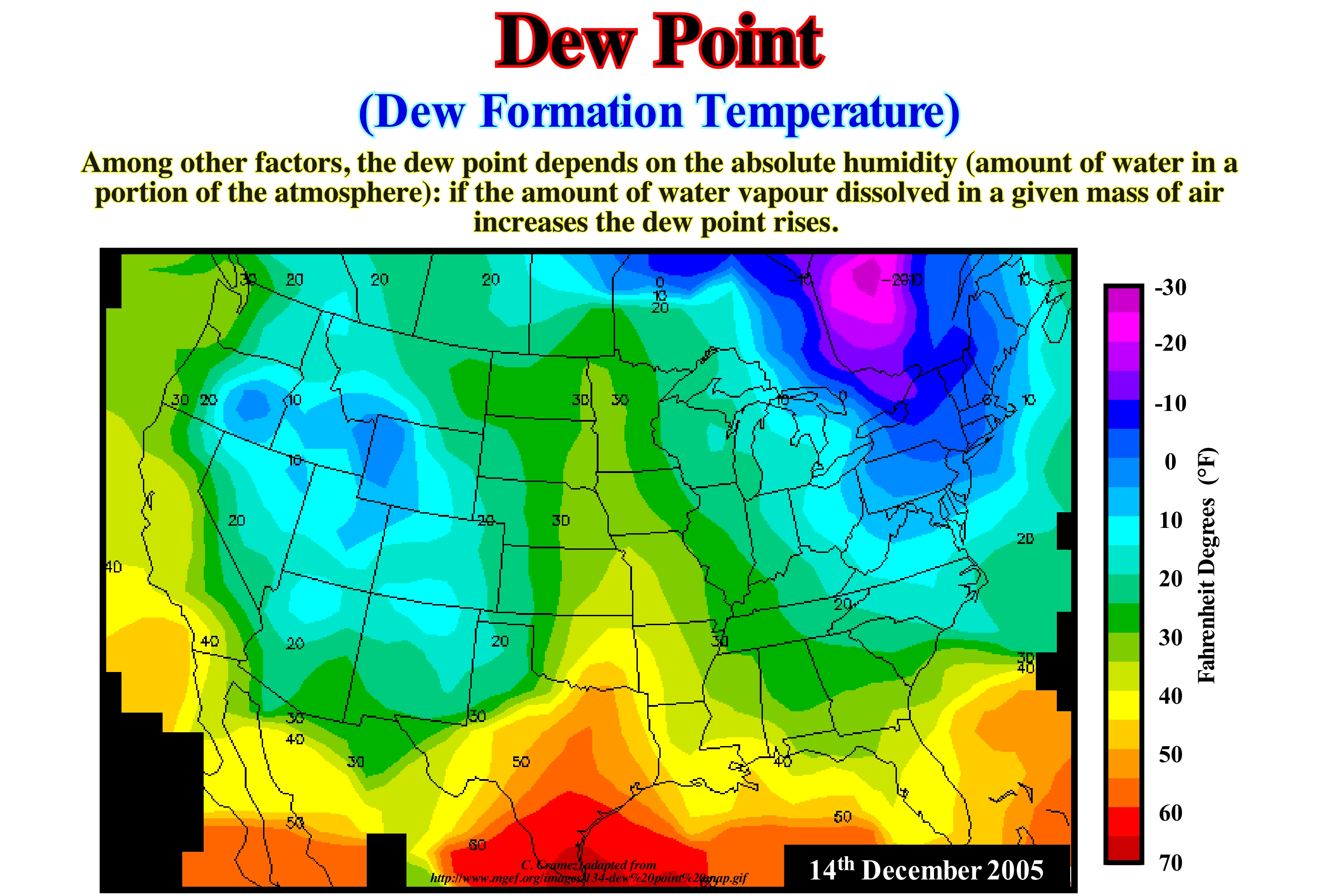
At a given barometric pressure, the dew point indicates the mole fraction of water vapour in the air, i.e., it determines the specific humidity of the air (ratio of water vapour in the air, including water vapour and dry air in a particular mass). The molar fraction can be expressed in two ways: (i) The molar fraction of the solute, i.e., the ratio of the number of moles of the solute to the number of moles of the solution and (ii) The molar fraction of the solvent, i.e., the ratio between the number of moles of the solvent and the number of moles of the solution. If the temperature rises without altering the molar fraction, the condensation point will remain unchanged, but the relative humidity decreases accordingly and the water continues to condense at the same temperature. An increase in the mole fraction, i.e. when the air becomes more humid, increases the relative humidity (amount of water vapour in a gaseous mixture of air and water vapour) from the air to its initial value. By lowering the mole fraction (less humid air) after the temperature goes down brings the relative humidity to its initial level. The same relative humidity on a day when the temperature is 27° C and on a day when it is 38° C implies that the air on the warmer day has more water vapor than on the cold day, that is, the dew point is higher. At a certain temperature, and independently of the pressure, the dew point indicates the absolute humidity of the air (amount of water in a given volume of air). If the temperature rises without changing the absolute humidity, the compensation point will rise accordingly and the water condenses at a higher pressure. By reducing the absolute humidity, the dew point returns to the initial value. By increasing the absolute humidity after the temperature drop, the dew point returns to its initial level. If the dew point and temperature in Geneva and Bern is the same, it means that the mass of water vapor per cubic meter of air will also be the same in both cities.
Diachronous (Lithology).....................................................................................................................................................Diachronique (Lithologie)
Diacrónica / Diacrónica (litología) / Diachrone / 历时态 / Диахронический / Diacronica /
When it des not have the same geological age. In geology, a lithology, i.e., a facies is diachronic if it does not represent the same period of time in all its extension.
See: « Lithostratigraphy »
&
« Chronostratigraphy »
&
« Chronostratigraphic Unit »

This tentative geological interpretation of a Canvas auto-trace of a detail of an Indonesia (East of the Borneo Island) offshore seismic line from, was made in sedimentary environments, i.e.,, independently of the chronostratigraphic lines, which, in general, coincide with the seismic reflectors. This type of interpretation corresponds to what some geoscientists, mistakenly call facies interpretation (see definition facies of Armanz Gressly). The interpreter (geoscientist in charge of this tentative interpretation) attempted to map the most probable deposition environments from the geometry of the chronostratigraphic lines (slope breaks). In this area, it is, relatively easy to identify the successive depositional coastal breaks of depositional surfaces which, more or less, coincide with the successive basin edges (continental edges). For most of the time, at the level of the sequence-cycles that constitute this offshore, the basin did not have continental shelf. This is particularly true on the seismic lines. The transgressive episodes are, little thick. They are under the resolution of the seismic lines. When highstand geological conditions predominate, the basin edge coincides with the continental edge, which corresponds, practically, with the coastal slope of the depositional surface (more or less, the shoreline), which, in turn, emphasizes the outer boundary of the delta plain. It may be said that near the depositional coastal breaks, delta or limestone sands were deposited, while upstream, in the coastal plain, siltstones, sands and clayey rocks were deposited. The facies (lithology with associated fauna deposited in a given sedimentary environment) of the delta front (sands and limestones) are diachronic. They were deposited in different geological times. The facies lines cut the chronostratigraphic lines, which are underlined by the seismic reflectors. On this tentative interpretation, the delta plain and the delta front refer to the delta building and not to a particular delta. It is particularly important not to confuse a delta with a delta building. A delta, in general, has a thickness that can range from a few meters to a few tens of meters. The thickness of a delta building, such as the one shown here (Mahakam delta building), may be several kilometers thick. Confusing a delta with a delta building is like confusing an apartment (delta) with a skyscraper (delta building). It is for this reason that the delta progradations, which form the slope of the delta, can, hardly, be identified on the seismic lines (most of the times they are below the seismic resolution). The most frequent error on the tentative interpretation of the seismic lines is to interpret a continental slope as a delta slope. However, in the highstand prograding wedges (HPW) or in lowstand prograding wedges (LPW), the continental slope may be a stacking of delta slopes. This geological interpretation, based on seismic packet patterns and calibrated by the results of the exploration wells, corroborates the conjecture that seismic reflectors follow time lines (chronostratigraphic surfaces) and not facies lines (lithological surfaces). In the 1960's, when oil company geoscientists began to use reflection seismic in oil exploration, reflectors, such as those illustrated in this auto-trace, were interpreted as facies lines (lithology). At that time, the seismic data were un-migrated. The seismic lines at that time had nothing to do with the modern seismic lines that any geoscientist with a minimum of geological knowledge can interpret, which was, obviously, not the case at a time when tentative geological interpretation of the seismic lines were, exclusively, made by geophysicists with little geological knowledge. Each reflector corresponded to an interface between different lithologies (clay-sand, sand-limestone, etc.). For instance, in this auto-trace, the C well recognized a level of limestone at the bottom of the well (underlined in red), the same limestone level was to be found in B and C wells when they crossed the same chronostratigraphic line, i.e., the same reflector. It was with these ideas that the geoscientists hoped to recognize and, above all, to follow in the seismic lines, the reservoir-rocks, since the acoustic impedance of the sandstones is much stronger than that of the shales of the prodelta or the silts of the delta plain. However, after several exploration wells, oil company geoscientists (particularly Exxon's geoscientists) calibrated the seismic lines in geological terms and concluded that the reflectors underline time lines (chronostratigraphic surfaces) and not facies (lithological changes) lines.
Diachronic Surface................................................................................................................................................................Surface diachrone
Superfície diacrónica / Superficie diacrónica / Diachrone Oberfläche / 跨时表面 / Диахронная поверхность / Superficie diachronous /
Surface with no chronostratigraphic value. A diachronic surface is independent of the stratification planes (time lines) to which it is often oblique. On the tentative of geological interpretation of the seismic lines, in which the reflectors are interpreted as chronostratigraphic lines, the geoscientist in charge of the interpretation must not forget the frequent presence of diachronic surfaces such as: (i) Contacts between different saturants ; (ii) Permafrost limits ; (iii) Bottom sea reflectors (BSR) ; (iv) Horizons rich in hydrates ; (v) Fault planes of low angle faults ; (vi) Subhorizontal igneous dykes ; (vii) Diagenetic surfaces, etc.
See: « Transgressive Interval »
&
« Chronostratigraphy »
&
« Maximum Flooding Surface »

In this figure are represented two tentatives geological interpretation of two Canvas auto-traces of two versions of the same seismic line of the south of the Ural Mountains. The left tentative (without correction) has no geological sense at all. It does not withstand a critical test (sediments can not be shortened as suggested), although the geometry of the reflectors is, exactly, what is observed on the seismic line. But a seismic line is a profile in time and not in depth. Probably in depth, the geometry of the reflectors, which are chronostratigraphic lines, is different. It should be borne in mind that the region where this line was taken is a permafrost region with lakes of variable depth (A Permafrost area is a land whose temperature remains below 0° C for more than two consecutive years. About 20% of the Earth's surface is, often, covered by a layer of icy land, called the "active zone", which melts in the summer allowing the development of vegetation. On the right (with correction), the tentative interpretation is that of a depth version of the same line, in which the effect of permafrost was corrected. In this tentative, the reflectors have a geological sense and correspond to undeformed time lines. The sediments are subhorizontal. As said above, on the left tentative interpretation, the geometry of the time lines have no geological value. They emphasize seismic artefacts induced by lateral velocity changes of seismic waves in the upper intervals affected by permafrost. This means that as a seismic line is a time profile, the geoscientist in charge of tentative interpretations has to pay close attention to the lateral variations of velocity. It may happen that an antiform structure in the seismic data corresponds, actually, that is, geologically, to a sub-horizontal geometry or even to a sinform structure. Examples of this type, i.e, examples of false structures are very frequent in evaporitic basin as the Lusitanian basin (Portugal). In fact, the lateral and vertical variations of the thickness of the salt horizon or even by its total disappearance (salt-welds), lateral velocity changes are paramount. The velocity of the seismic waves in the evaporitic horizons is much higher than in the shaly sediments. A lateral variation of the thickness of these horizons induces a pull-up of the base which, automatically, raises the underlying horizons. Such a pull-up is simply a seismic pitfall (parasite resulting from the processing) and should never be interpreted as the result of a tectonic deformation without first having been subjected to various refutation tests. The presence of diachronic surfaces is, frequently, associated with: (i) Saturated contacts; (ii) Permafrost ; (iii) Clathrate rich horizons ; (iv) Low angle fault planes ; (v) Subhorizontal igneous dykes; (vi) Diagenetic surfaces, etc. Diachronic surfaces, oblique to chronostratigraphic lines, are, sometimes, found on seismic lines, in association with accumulations of hydrocarbons. Likewise, in the deep offshore seismic lines, diachronic horizons, which emphasize the top of the clathrates levels, mimic, sometimes, the sea floor, as illustrated in this figure by a Canvas auto-trace of a seismic line of the NW Colombia offshore. On this tentative interpretation a diachronic seismic reflector is, easily, recognized about 0.5 seconds below the sea floor. This reflector, which simulates the bottom of the sea (BSR or Bottom Simulating Reflector) is caused, mainly, by the gas bubbles at the base of the gas hydrate stability zone (GHSZ), which, consequently, can not act as a cover. The porosity is filled to more than 95% by water. The gas hydrate stability zone occurs in oceanic sediments in the first few hundred meters below the sea floor. In this zone, any methane from an organic material, including any exudation from deeper areas, is converted to a solid hydrate, and is blocked in the sediments. The origin of methane is poorly understood. Even its biogenic origin is being challenged.
(*) Water clathrates are mistakenly known as hydrates, causing confusion with sugars (carbohydrates). The most important are methane hydrates, which are found in sediments near the bottom of the oceans and which certain geoscientists think could be used as an energy source. Other geoscientists even think that clathrates could be used to facilitate the transport of methane, which is now made through pipelines or liquefied at -182.5 ° C or at high pressure (200 bar).
Diagenesis .............................................................................................................................................................................................................................Diagénèse
All the physical, chemical and biological changes undergone by the sedimentary particles from the moment of deposition until their conversion into solid rocks and, subsequently, till the beginning of metamorphism.Diagénese / Diagénesis / Diagenese / 成岩作用 / Диагенез / Diagenesi /
See: « Deposition (carbonates) »
&
« Differential Compaction »
&
« Rock Cycle »
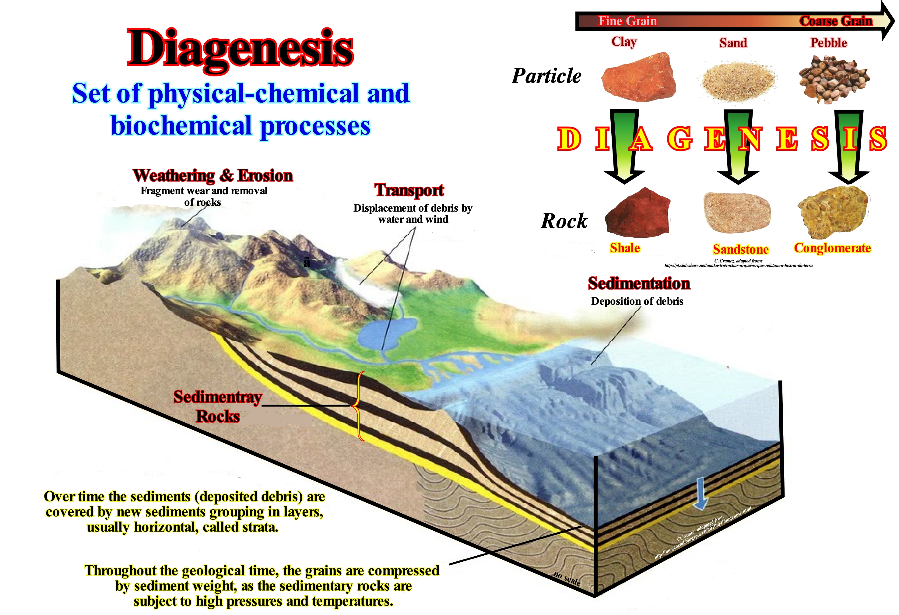
After deposition, the sediments are, progressively, compacted as they are buried beneath the layers, deposited, successively, and cemented by minerals, which precipitate from the solutions that fill the space between the grains, i.e., between the pores. Grains, sedimentary particles, rock fragments, as well as fossils, can be replaced by other minerals during diagenesis. The porosity, that is, the percentage of the void volume or containing the fluids, decreases during diagenesis, except in rare cases of dissolution of certain dolomitization* minerals. Diagenesis does not include the processes of weathering. The physical, chemical and biological processes that decompose a rock, in general, to the Earth's surface (pressures and low temperatures) in the presence of air and water. The formation of hydrocarbons or, in other words, the formation of oil and gas from the organic matter of the potential source-rocks also begins during diagenesis, which, in certain limits, distinguishes itself, badly, from metamorphism (transformation, without change of state, structure or chemical or mineral composition of a rock that is subjected to conditions of temperature and pressure other than those that gave rise to it or when receiving an injection of fluids). The fundamental difference between diagenesis and metamorphism is that metamorphism occurs at high temperatures and pressures in a domain deeper than that of diagenesis. In certain diagenetic processes, as shown in this figure, a mineral (paleosoma or primary mineral) may be replaced by another (metasoma or secondary mineral). Such a process involves two simultaneous chemical reactions: (i) Dissolution of the original mineral (paleosoma) and (ii) Precipitation of the secondary mineral (metasoma). The chemical reactions occur at the same volumetric rate, i.e., without volume variation respecting the law of Goguel (a very old hypothesis that during the deformation the volume of the sediment remains, more or less, constant, but that it took a very important place in geology with the works of Goguel, who introduced the second principle of thermodynamics in geology and in particular in tectonics). This process is, particularly, well illustrated by the dolomitization of calcite in which the dolomite crystals replace foraminifera and echinoderm bioclasts (visible structures are the residual images of the original allochemical structure**, that is, the grains that can be recognized on the rocks carbonated). It may be said that by diagenesis, for instance: (i) A set of clays or silts (particles) are transformed into a shale or a siltstone, that when fissile, that is to say, when they break in thin lamellae parallel, to the bedding planes (difficult to recognize) ; (ii) A set of sands becomes a sandstone and (iii) A set of gravel becomes a conglomerate. In summary, it can be said that: (i) The various parameters and processes responsible for diagenesis are not assembled in a random way ; (ii) Some parameters (pressure, temperature) vary approximately linearly with depth, but others, such as oxidation-reduction, define clear limits (limit surface Eh = 0 between the oxidation zone and the reduction zone at the beginning) ; (ii) Combinations of various agents allow to distinguish several phases and various areas of diagenesis: a) Initial Phase or Oxidation Phase, during which the sediments are deposited as a moving ooze, water allows exchanges with the external environment (usually sea water) ; b) Phase of reduction, in which the anaerobic life predominates; c) Compaction Phase, which marks the beginning of compaction with redistribution of material in the sediments (cement formation and concretions) and d) Consolidation Phase in which the sediments become sedimentary rocks.
(*) Dolomitization is a process of extreme importance in the scope of the petrogenesis and alteration of the rocks. This process influences the porosity of the rocks, with important implications in petroleum geology. Although dolomite may form in a primary sedimentary process with deposition of magnesium carbonate instead of calcium. It is, generally, associated with a secondary process of alteration of calcium carbonate-rich formations, where occurs substitution of calcium ion occurs by magnesium, which implies large-scale recrystallization, which generally causes the primary sedimentary structures to disappear. (http://geocientista.blogspot. ch/2014/04/processos-de-dolomitizacao-durante.html)
(**) The term allochemical is now more, generally, used to denote one or more varieties of the more or less organized large carbonate aggregates which form the granular structure of most mechanically deposited carbonates. Allochemicals, which contrast with the interstitial material, such as calcite of a calcareous cement or matrix, include intraclasts, oolites, fragments of fossils, etc.
Diastem......................................................................................................................................................................................................................................................Lacune
Lacuna / Lacuna / Diastem (Kleine Hiatus) / Diastem (小间隙) / Углубление, впадина / Diastem (piccolo iato) /
Relatively short interruption of sedimentation over a time interval with almost no erosion before deposition resumes. A diastem is sometimes called the stratigraphic gap to emphasize that it corresponds to an interruption found in a stratified series. It can also be called a hiatus and may be caused by nondeposition (stratification gap) or by erosion (erosion gap). Diastem is synonym with Lacune and Hiatus.
See: « Hiatus »
&
« Deposition (carbonates) »
&
« Completeness »
Clastic sedimentary particles deposit in layers because the water and wind tendency to disperse sediments of the same type over relatively thin horizons over a large extent during, more or less, constant environmental conditions. A diastem is a minor hiatus in an orderly succession of sedimentary rocks. It is an interruption in the stratigraphic record, which may be the result of a local erosion or an interval without deposition and representing a small geological time interval. Interruptions by nondeposition occur more frequently within certain sedimentary environments than in association with environmental changes. A period of nondeposition may be the result of excessive turbulence in a given environment or a sediment transport deficiency. Discontinuities in sedimentation occur at all scales. Small interruptions (ranging from seconds to days) are associated with layer migration, sea wave variations or current energy, as well as tidal cycles. The deposits associated with seasonal variations form during floods, storms, cyclones, etc. They can occur on a scale from decades to hundreds of years. In deep sedimentary environments, the deposition of the turbidite layers is considered, geologically, as a snapshot (hours), while the deposition time of the pelagic horizons, which lie between them (usually not very thick), can be hundreds of thousands or even millions of years. All the bedding surfaces, such as those illustrated in this photograph of the "Creux du Van" rocky circus (Canton of Neuchâtel, in Switzerland), which is about 1,400 meters wide by 200 meters high, represents a short time of interruption or hiatus. If the gap is, sufficiently, large, the surface corresponds to an unconformity (the limit of a stratigraphic cycle), whose age is given by the age of the submarine basin floor fans that rest, by marine onlaps, against the correlative paraconformity of the unconformity in deep water. Bedding surfaces may have a different gap from one place to another. Bedding surfaces always have a small unit of time that is common to the entire surface. The concept of bedding surface is entirely dependent on the time scale and the rocks considered. As the time corresponding to the absence of sedimentation, which produces a discontinuity that can have very distinct values. Certain geoscientists differentiate between hiatus, diastem and gap : (i) Hiatus, when the duration is very short ; (ii) Diastem, when the interruption is short without modification of sedimentation conditions and (iii) Gap when the duration is significant and can be evaluated, biostratigraphically, as the gap of a biozone. A stratigraphic surface can be considered as a continuous physical boundary. At least three large groups of stratigraphic surfaces may be observed in the field or on the seismic lines: (i) Stratal surfaces - bedding planes and chronostratigraphic reflectors are stratal surfaces; a seismic reflector represents a, more or less, thick seismic interval whose thickness depends on the seismic resolution and which can vary between 10 and 100 meters ; (ii) Discontinuity surfaces (*), which are physical surfaces caused by erosion or non-deposition, and which may be: a) Unconformities, when caused by erosion ; b) Paraconformities, when they separate, more or less, parallel strata with a gap of no deposition ; c) Depositional hiatus, which can be defined by toplaps/downlaps (sub-aerial/underwater environments), downlaps/apparent truncations (underwater/subaerial environments), onlaps/conform (underwater/underwater environments) ; (iii) Diachronic surfaces, which include transgressive retrogradational surfaces and, on the seismic lines, the reflectors associated with the gas/oil-water contact planes, which may be either synchronous (parallel to the stratal surfaces) or diachronic (oblique to stratal surfaces).
(*) A discontinuity designates a transition or contact between intervals with either different densities (Mohorovičić discontinuity) or with different sedimentary facies or between intervals separated by a hiatus. There are several types of discontinuities: 1- Stratigraphic ; 2- Sedimentary ; 3-Lithologic ; 4- Tectonic, etc. Within the lithological discontinuities can be recognized: (i) Concordant Discontinuities, when there is continuity between successive intervals; (ii) Paraconform Discontinuities or Paraconformities, when there is no difference in attitude between overlapping intervals, but there is a hiatus due to the absence of significant deposition between them ; (iii) Non-Conform Discontinuities or Non-Conformities, when there is a contact between a sedimentary interval and an older igneous body ; (iv) Disconform Discontinuities or Disconformities, when the layers of the gaps are parallel on either side of the contact surface which does not conform to the regional stratification ; (v) Discordant Discontinuities or Unconformities when the two intervals are separated by an erosional surface induced by a relative sea level fall ; (vi) The Reinforced Discordant Discontinuities or Tectonically Enhanced Unconformities, when the sediments of the interval overlying an unconformity were deformed by tectonics ; (vii) Intrusive Discontinuities, when an igneous body traverses a sedimentary set ; (viii) Mechanical Discontinuities, when they are induced by faults, etc. (https: //estpal13.wordpress.com / 2013/06/04 / discontinuities-sedimentary-and-stratigraphic)
Differential Compaction..................................................................................................................Compaction différentielle
Compactação Diferencial/ Compactación diferencial / Differential-Verdichtung / 差异压实 / Дифференциальное уплотнение / Compattazione differenziale, Costipamento differenziale /
Reduction of sediment volume due to porosity behaviour, such as between clayey and sandy rocks, which creates a significant reduction of the thickness of the most compactable sediments in relation to the less compactable. Differential compaction is, largely, responsible for the inclination changes of fault planes (particularly normal faults), when faults occur prior to compaction.
See: « Cementation »
&
« Sequence Stratigraphy (sequential) »
&
« Lithostratigraphy »
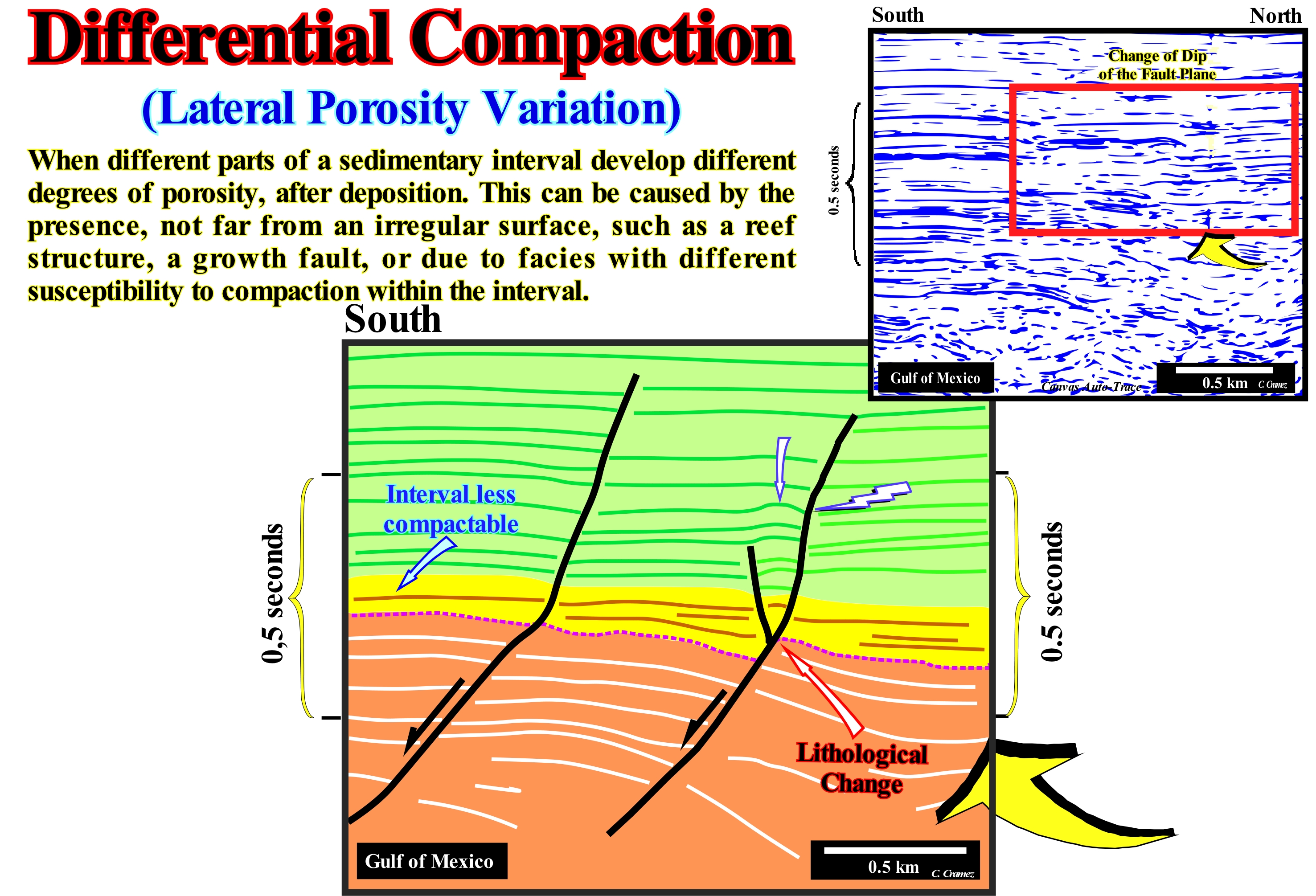
The Gulf of Mexico corresponds to a stacking of several types of basins of the classification of the sedimentary basins of Bally and Snelson (1980). From bottom to top, it is easy to recognize on regional seismic lines: (i) A Paleozoic Folded Belt (Appalachian Folded Mountains) ; (ii) Triassic Rift-type Basins ; (iii) A Divergent Atlantic-type Margin ; (iv) A Panonian-type Basin and (v) A Mediterranean-type basin. After the break-up of the lithosphere of the Panonian-type basin, which preceded the Mediterranean-type basin, significant sub-aerial lava flows occurred. On this tentative interpretation of a detail of a Canvas auto-trace of an offshore seismic line, the geometry of the fault planes, as well as the small antiform structures located in the foot-walls, are created by differential compaction between the layers (or groups of layers), less or more, compactable. This fact is widely used by geoscientists, who interpret seismic lines in geological terms, to advance hypotheses about the lithology of certain seismic intervals. In a sedimentary column, where alternating intervals with different compaction, such as alternation of sandstones and shales, all fault planes prior to compaction are deformed. The dip of the fault planes decreases in the most compactable intervals (shaly rocks, for example), while it remains, more or less, constant in the less compactable intervals (sandstones, calcareous, etc.). In the case of normal faults, when, locally, the dip of the fault plane decreases, space is created in the hanging-walls (upper block). The sediments of this faulted block are obliged to lengthen to fill the space created in order to respect the law of Goguel (during the deformation the volume of the rocks remains more or less constant) and the geological principle that nature has horror of emptiness. Such elongation is usually made by small antiform structures (not to be confused with anticline structures, which are shortening structures), with a bell-shape, like the anticlines, but affected by small normal faults, whose throws are almost always inferior to the seismic resolution. They are structures of lengthening (extensional structures for certain geoscientists). All this is illustrated, in this tentative geological interpretation of an auto-trace of a Gulf of Mexico seismic line. The dip changes of the fault planes are evident, as well as the antiform structure in the hanging-wall of the fault located further north. Likewise, the less compactable seismic interval that, probably, corresponds to an interval where reservoir-rocks predominate (sandy lithology), is identified, easily, in the foot-wall blocks. The faulted blocks of a normal or reverse fault may also be called failure lips. The hanging-wall is also called the fault roof or top and the foot-wall block corresponds to the lower fault block of certain geoscientists. This tentative interpretation, clearly, shows that on seismic lines or the auto-traces, the picking of fault planes* is a fundamental stage of interpretation, when faulting pre-dates the compaction, i.e., when Anderson's law can apply easily. Such picking is done in several steps: (i) Mark the reflector terminations that underline the mechanical discontinuity (truncation) induced by the relative movement of the faulted-blocks ; (ii) Joining the reflector termination of the foot-wall and hanging-wall, i.e., tracking the seismic surfaces that limit above and below the fault zone ; (iii) Locate, in the foot-wall, the sedimentary intervals, in which the dip of the fault plane is more vertical, which probably correspond to intervals formed by rocks that suffer less compaction (potential reservoir-rocks) ; (iv) Locate in the hanging-wall, the accommodation antiform structures: the vertical passing through the apex of the structures intersect the fault plane in a a zone of lithological change.
(*) On seismic lines, the vast majority of fault planes are not underlined by seismic reflectors, except when: (a) The fault plane is injected by salt ; (b) The fault plane is injected by volcanism ; (c) When the relative movement of the failed blocks created a fault zone, more or less, filled by shaly sediments ; (d) The fault plane corresponds to a contact between sedimentary rocks and a basement with a strong acoustic impedance ; e) When the fault plane is slightly inclined (near the horizontal).
(**) This law suggests the dip of the fault plane is for normal faults about 60 -70°, about 20-30° for the reverse faults and more or less 90° for strike-slip faults.
Diffraction (Seismic wave)..................................................................................................................................................Diffraction (Onde sismique)
Difracção / Difracción (onda sísmica) / Diffraktion (seismische Welle) / 衍射(地震波) / Дифракция (сейсмической волны) / Diffrazione (onde sismiche) /
Radial dispersion of incident seismic energy on abrupt discontinuities along the seismic interface, particularly, in structures where the curvature radius is shorter than the lengthwave of the incident wave, i.e., in areas where reflection and refraction laws are not respected.
See: « Lateral Reflection »
&
« Snell's Law»
&
« Positive Reflection »

The analogy between the theory of seismic rays and optics generalizes the concept of diffraction, which can be defined as the transmission of energy by a radius of non-geometric path. In the seismic data, the diffraction occurs when the radius of curvature of the reflecting surface is smaller than some wavelengths of the incident wave. The Fresnel Zones theory says the waves are reflected from a more or less large area (Fresnel zone) and not from a single point. According to this theory, a ray that reaches the end of a reflector, regardless of the geometry of its trajectory (straight line), an observer can not see it (what it reflects is an area and not a point), since the energy is diffracted around the end of the reflector. The first zone of Fresnel can be seen as that of a cone, which has as its apex at the end of the reflector. Diffractions occur at the terminations of the reflectors, as in the case of a fault. They are, in general, hyperbolic and cross the other reflectors, which means they have no chronostratigraphic value. In this non-migrated seismic line, there are a large number of diffractions, which suggest the existence of discontinuities between two faulted blocks. In the foot-wall block (left) the amplitude of the diffraction is greater than that of the reflections. In the lower left corner, the diffractions are probably created by a point located outside the plane of the seismic profile. Conversely, to a very accepted idea, waves, like, light waves do not propagate in a straight line, but according to a trajectory that takes them less time. When there is a fault on a seismic line, the fault plane can be defined by the line passing through the apexes of the diffraction as shown above. The hyperbolic form of the diffraction is due to the hypothesis of the CDP (Common Depth Point) method, in which the source and its trace are displaced from a certain distance below the line of fire, so that the reflections of the same layer are captured by the geophones in slightly different positions and that a reflection is created by the midpoint between the geophone and the source.
Diffluence (Defluviation).............................................................................................................................................................Diffluence (Défluviation)
Difluência / Derivación, Difluencia / Diffluenz / 分流 / Дифлюэнция (разжижение) / Derivazione /
Branch of a river or tidal channel in arms that separate without reuniting. A diffluence occurs when the slope of the longitudinal profile of the talweg is very low and the channel is inserted in a surface subject to flooding. The branching point is the diffluence point.
See: « River »
&
« Distributary »
&
« Delta »
The areas of diffluence are important in sequential stratigraphy. They are very sensitive to relative sea level changes. The provisional equilibrium profile profile of the main stream and its branches is, practically, subhorizontal. A small rise of the relative sea level (combined action of the eustasy and tectonics, i.e., subsidence or uplift o the sea floor) will cause a total flood of the area destroying a large part if not the totality of the overbanking deposits, particularly, of the natural marginal dykes (levees) and the river arms. A relative sea level fall, even small, will displace, seaward and downward, of the shoreline and associated coastal deposits. The relative level at sea will be lower than the basin. The old coastal platform will be, totally, exhumed and exposed to the action of erosive agents. As the shoreline is displaced seaward and downward, the provisional equilibrium profile the main water-course and associated arms (the equilibrium profile of a water-course is never reached) is broken, which force the streams to incise the their beds so that a new provisional equilibrium profile is later achieved. At the same time, the delta landform and the diffluence point moves downstream of the basin edge, creating, if the conditions are favourable, a delta in the lowstand prograding wedge which will begin to deposit since the relative sea level rise again. All this creates incised-valleys, which are one of the manifestations of the erosional surface, i.e, of the unconformity created by the relative sea level fall. When the relative sea level rise is significant, the lowstand prograding wedge (LPW) reaches its terminal phase. The relative sea level level will begin to flood and filling with sediments the incised valleys that will be fully filled with sediments at the flooding peak of the area, i.e., at the time of the first transgressive surface, which, again, will displace the shoreline continentward. Such a displaced individualises a new basin edge landward of the continental edge, that stays, more or less, in same position (limit between the coastal plain and continental slope of the lowstand prograding wedge).
Digitated Delta (Finger delta).................................................................................................................................................................Delta digité
Delta digitado / Delta digitado / fingert Delta / 手指三角洲 / Пальчатая дельта / Delta dita /
When the delta plain extends through several narrow, long, finger-shaped lobes or with a bird foot like morphology.
See: « Delta »
&
« Cuspate Delta (blunt delta) »
&
« Delta Plain »
The Mississippi Delta Building is a typical example of digitated or finger delta. The delta, itself, was constructed mainly by the alluvium deposited by the river, which lost competence entering the Gulf of Mexico. The delta building of the Mississippi corresponds to a progradational stacking of a large number of deltas of average thickness between 30-50 m. A delta building is similar to a skyscraper, which is the stacking of floors (apartment) of more or less less, 2.4 meters high. A delta slope (set of seaward dipping delta layers) should not be confused with the continental slope, which, in the case of a delta building, may correspond, more or less, to the overlapping of several delta slopes. This is the case when, within a sequence-cycle, the basin has no shelf, that is to say, when the lowstand prograding wedge (LPW), for instance, consists of an stacking of deltas. In these conditions, the shoreline corresponds, more or less, to the continental edge that functions, also, as basin edge. In the same way, during the 2nd stage of development of the highstand prograding wedge (HPW), the continental slope may be the result of the development of a delta building. Another case in which the continental slope may be the result of a more or less vertical accumulation of small delta slopes is the overlapping of a series of incomplete sequence-cycles formed just by lowstand or highstand prograding wedges. In this case, it can also be said, collectively, the continental slope corresponds to the, more or less, progradational stacking of delta slopes. In the top of the continental slope, which may be hundreds to thousands of meters, is localized a delta slope of some tens of meters of height. The deltas that make up the Mississippi Delta Building have developed in an area characterized by: (i) Wave action so weak that the amount of sand that is transported to the beach is less than the sand dispersed offshore by storms ; (ii) A difference between low-tide and high-tide is around about 30 cm which, however, is sufficient to play an important role in sedimentation, since the delta gradient is very small ; (iii) Strong subsidence (30-60 cm per 100 years), induced by compaction of recent sediments. Recent sedimentation processes (from 7,000 / 5,000 years ago) displaced the shoreline downstream, between 30 and 80 km*. Several times, more or less, every 1,000 years, the main stream changed bed creating different sets of delta lobes. Each set appears to have been initiated by the gradual capture of the main current by one of its distributaries. During the construction of the deltaic building, six main lobes were formed: (a) Maringoiun ; (b) Teche ; (c) St. Bernard ; (d) Lafourche ; (e) Achafalaya and (vi) The recent lobe. The lateral displacement of these lobes, probably associated with a pendulum effect, created, locally, transgressive episodes, which should not be confused with the two global transgressive episodes created in this area by glacio-eustasy: (1) Brackish Ingression, when lakes, bays and lagoons covered alluvial sediments of the deltaic plain and (2) Marine Ingression, when the shoreface of the barrier-bars advanced continentward. The first was done, practically, without ravinment, which, in the marine ingression is quite important. When the relative sea level rises the shoreline is shifted continentward. It is what the geoscientists call marine ingression. However, a marine ingression may be in acceleration or deceleration. When the relative sea level rises in acceleration, collectively, i.e., with the associated sedimentary regressions, the shoreline moves continentward. This is what geoscientists call sedimentary transgressions. A set of increasingly large marine ingressions and associated increasingly smaller sedimentary regressions, globally, create a retrogradational geometry, which were, collectively, termed transgressions by C. Emiliani (1992). The term transgression to designate the displacement of the coastal deposits continentward is inappropriate. In isolation, all the sequence-paracycles progradate seaward. There is no clastic sedimentary particles (sediments for some geoscientists), that come from the sea, unless they are remobilized.
(*) A displacement of the shoreline seaward, generally, corresponds to what the geoscientists call a sedimentary regression when, at the hierarchical level of a sequence-cycle, it is the result of the gradual progradation of coastal onlaps seaward during periods of relative sea level stability that occur after each marine ingression in deceleration (marine ingression smaller than the previous one).
(**) The capture of a water-course is a hydrographic phenomenon in which the erosion of a river opens a breach in the bed of another stream, more or less, perpendicular, capturing its waters, leaving it without flow. Different types of captures were proposed by Christofoletti (1975): (i) By Absorption ; (ii) By Retreat of Headwaters ; (iii) By Lateral Flattening ; (iv) By Overflow and (v) By Underground Erosion.
Dip (Bed).............................................................................................................................................................................................................................................Inclinaison
Inclinação / Inclinación / Inklination / 地质浸 / Искривление скважины /Inclinazione /
Maximum angle by which a bed or other plane sedimentary object deviates from vertical. The dip of a layer is measured in the plane perpendicular to its strike. Angle formed by the line of greater slope, drawn on the surface of the layer, and its projection on the horizontal plane.
See : « Stratal Pattern »
&
« Strata »
&
« Depositional Dip »
The terms strike and dip refer here to the orientation and attitude of a geological element. The strike of a layer or a fault or any other planar geological element is the line representing the intersection of that element with a horizontal plane. In a geological map, this is represented by a small dash oriented parallel to the strike. The dip is the steepest angle of a layer or plane relative to a horizontal plane. The dip of a layer or group of layers may be depositional or structural. The depositional dip is original. It corresponds to the angle at which a layer or group of layers was deposited. At the macroscopic scale (i.e., at the scale of a sedimentary basin), the depositional dip is always towards the deepest part of the basin. Structural dip is the slope of a layer or a group of layers obtained as a result of a tectonic deformation, whether induced by an extensional tectonic regime (lengthening) or compressional (shortening). The term "compression" may be misleading. There may be lengthening with a positive tectonic stress. In an extensional regime (σ1 vertical, i.e., with vertical main effective stress), the rocks are lengthened by normal faults (there are no vertical normal faults). The layers almost always dip towards the subsidence zone created by the lengthening . That is why when the extensional regime is contemporaneous with the deposition, the thickness of the layers and, consequently, the dip, increases towards the subsidence zone created by the lengthening. In compressional regimes (σ1 horizontal), the rocks are shortened, which implies an uplift, that is, there is probably an associated erosional surface and not a subsidence, as is the case in an extensional tectonic regime. The shortening can be done by the formation of folds (anticlines and synclines) or by the development of reverse faults. In both cases, almost always, the beds dip in the opposite direction to the uplift area. However, in an anticlinorium (large anticline with small anticlines and synclines in the flanks), the beds dip in the opposite direction to the uplift, although on the flanks the beds can have dips with different polarity. These seemingly anomalous dips in relation to the macroscopic structure respect the same rule, but on a mesoscopic scale, since the anticlines and synclines located on the flanks of the anticlinorium have another order of magnitude. Do not forget that what deform the rocks is not the tectonic vector (σt), but the effective stresses (σ1, σ2, σ3), that is to say, the sum of the geostatic pressure (σg), hydrostatic pressure or the pore pressure (σp) and the tectonic vector (σt), whose ellipsoid can be raised, that is, narrow (i.e., the major axis is vertical), when the tectonic regime is in extensional, or oblong, that is, lying down (σ1 horizontal ) when the tectonic regime is in compressional. The geostatic pressure (σg) of a given point is the weight of the sedimentary column above that point. The hydrostatic pressure or pore pressure (σp) is the pressure exerted by the water column from a point on a rock to the depth. The tectonic vector (σt) represents the tectonic force, in general, horizontal, which is almost always induced by the movement of the lithospheric plates. Particular attention must be paid to the slope of the seismic reflectors. A seismic line is a time section and not a depth section, such as a geological section (natural scale 1: 1 or no, the vertical scale is always metric). The true slope of a seismic reflector can be just obtained ion a depth and 1: 1 scale version, that is to say, in a depth version of the seismic line and when the horizontal scale is equal to the vertical scale. In conclusion: (i) The dip of a bed is the smallest angle that it forms with the horizontal plane ; (ii) The strike of a bled is given by the angle formed by the intersection of the bedding plane with the horizontal plane, i.e, the angle between the North and the intersection line of the plane considered with the horizontal plane ; (iii) The dip of a bed is the acute angle between the horizontal plane and the plane of the concerned bed, measured perpendicularly to the line of intersection of the planes. In the field, to determine the dip of a bed with a compass with clinometer, proceed as follows; a) Align the direction E-W of the compass with the reference line of the compass ; b) Attach the large compass needle to the layer ; c) Record the dip value indicated by the clinometer on the graduated scale (0° to 90°) ; d) Determine the quadrant for which you see the direction of the dips of such a plane (NE, SW, etc.).
Dipmeter Log ...................................................................................................................................Diagraphie de l'inclinaison (Dipmeter)
Diagrafia de inclinação / Perfil de buzamiento (dipmeter) / Dipmeter log, Kippen-Protokoll / 倾角, 记录的倾向 / Наклонометрия скважины / Dipmeter, Registro d’inclinazione /
Electrical log showing the magnitude and azimuth values of the layers crossed by a well, in general, an exploration well.
See: « Electric Log »
&
« Unconformity »
&
« Fault »

The dipmeter measures the dip direction the layers adjacent to a bore-hole. Basically, it is a multi-arm micro-resistivity diagraphy. Three or four arms of a probe separately record the micro-resistivity within a well, while a magnetic compass records the orientation of the probe as it is withdrawn from the well. A computer correlates the four micro-resistivities measures and calculates the magnitude and direction of the bedding planes and determines the consistency of the calculation. In a dipmeter log four patterns are possible: (i) Set of uniform and low dips (green pattern), which correspond, in general, to the dip of the shales, which indicate the structural dip of the layers ; (ii) Set of upwards decreasing dips (red pattern), which can be caused by the compaction of the shaly rocks overlying the reef, sandy barrier- bar, filling of a channel by sands or by the occurrence of folds, faults or tectonically enhanced unconformities ; (iii) A set of upward increasing dips (blue pattern), which may be caused by the slope progradations of a reef, a sandy body, the presence of submarine fans cones (basin floor fans or slope fans), a delta, a fault, a fold or an unconformity; (iv) Set of chaotic dips, which can be induced by bad conditions of well walls or by the presence of fractures, landslides or any other geological structure with chaotic internal configuration. The interpretation of dipmeter logs, which indicates the magnitude, direction, and direction of the dips of the layers, is an important step in sequential analysis. It allows to control the location of the tectonically enhanced unconformities (angular unconformity) and, in certain cases, the different sedimentary systems tracts that make up a sequence-cycle. The dispersion of the dips can give valuable indications about the sedimentary environment of the different intervals traversed by a well. The dispersion depends very much on the energy of deposition. Pelagic shaly rocks, for instance, are characterized by poor dispersion, which is not the case with the sandy filling of a channel.
Disaggregation, Disintegration (Rocks)................................................................................................Désagrégation
Desagregação / Desagregación / Auflockerung, Auflösung / 解体 / Разрушение (размельчение) / Disaggregazione, Disintegrazione /
Separation or reduction of an aggregate (rock) in its components (sedimentary particles). Mechanical alteration, i.e., process of disintegrating a rock by the action of ice, crystal growth, water absorption and other physical processes, are typical examples of disintegration.
See: « Erosion »
&
« Sedimentation »
&
« Transportation (sediments) »

As all geoscientists know, there are three main classes of terrestrial materials. The first accretions of the Earth's crust are in the form of molten magma, which when it cools solidifies either in volcanic glass or in an aggregate of minerals. Such rocks are designated as igneous or magmatic rocks. Sedimentary rocks result from a mechanical accumulation of pre-existing particle fragments as well as from chemical precipitation from water. Metamorphic rocks include all other rocks whose original minerals and/or textures have been, significantly, altered by variations in temperature and pressure and/or deformation. Typically, metamorphism occurs at considerable depths within the Earth's crust. The soils result from the chemical alteration and mechanical disaggregation of the rocks. The disintegration of a rock can be done in different ways, which can be grouped into two great classes: (i) Mechanics, such as a rupture of the rock into smaller pieces, that is without composition change, or by Fracturation or disintegration of the crystals forming it, and (ii) Chemistry, for example by transformation or decomposition of one mineral into another by chemical processes, in which water acts as a very important agent. Among the various mechanical processes that create fractures in rocks, the most common are: (a) Expansion/Compression, significant temperature and pressure changes induce compression and expansion phases that fracture rocks, especially when the minerals that comprise them have different expansion and contraction rates ; (b) Tectonic Regime, whatever the orientation of the σ1*, (vertical or horizontal) of the ellipsoid of the effective stresses, the rocks when submitted to a tectonic regime always fracture parallel to the σ2 ; (c) Unloading by erosion. Among the processes that increase the size of the fractures, the compression by freezing and root growth of plants are the most common. The photograph on the left illustrates the breakdown of granitic rocks on the NW French coastline , while the photograph on the right illustrates the breakdown of the turbiditic layers in the San Diego (USA) coastline.
(*) σ1 is the major axis of the effective stress ellipsoid (combination of geostatic pressure, σg, pore pressure, σp, and tectonic vector, σt). In a tectonic regime, when the σ1 is horizontal, the rocks are shortened, when σ1 is vertical, the rocks are elongated. All faults, whether normal or reverse, are always parallel to σ2, which is the mean axis of the ellipsoid of the effective forces.
Discharge Current (Hydraulic compensation current).............................................................Courant de décharge
Corrente de descarga / Corriente de compensación hidráulica / Auslad Strömung, Löschung Strömung / 液压电流 / Стоковое течение / Corrente di compensazione idraulica /
Acceleration and inversion of water flow over an obstacle or fall. Never fight against a discharge current. Instead, dive to the bottom of the stream and swim, leisurely, to the edge of the current where its action is no longer felt. Synonym with Hydraulic Compensation Current.
See: « Stream »
&
« Upwelling Current »
&
« Capsinzing Current (wind) »

As illustrated, a discharge or hydraulic current forms, for example, when water flows along a dam or waterfall with a volume and force sufficient to create, in the surface, a return wave (in the opposite direction), which can obstruct much of the flow. Discharge currents are recirculation currents produced when water falls over an obstruction and plunges to the bottom with such force that it creates a cylindrical wave that returns to the surface and returns to the fall (difference in altitude of the water level) that cause it. Depending on the height of the fall and the volume of water that plunges, a discharge current can be very strong and be a trap for boats and, unfortunately, sometimes also for people. The size of a discharge current can be calculated by the distance between the upwelling spiral of the return wave and the obstruction (fall). If the return wave begins to curl back 2 meters after the obstruction, the hole underneath the fall will be about 2 meters deep. This is not an absolute rule. The conditions of bed of the current may create a situation different from that observed on the surface. However, we have every interest in taking it into account. It gives us an idea of the depth of the hole where the discharge current is formed, which is very important in case of self-rescue. The technique of exiting a discharge current is, totally, contrary to the natural instincts: (i) Put yourself in a foetal position (the back is curved, the head is bowed, and the limbs are bent and drawn up to the torso) ; (ii) Let yourself go the bottom of the current ; (iii) When reaching the bottom, extend yourself (face up and feet down) and let that he strong basal current take you out of the danger zone, then swim to the surface of the water. Of course, start by taking a deep breath, as this can take a minute or two.
Disconformity.................................................................................................................................................................................................Desconformité
Disconformidade / Disconformidad / Disconformity, Nichtkonformität / 不合格 / Несогласие / Disconcordanza, Non conformità /
When the strata or seismic reflectors are, more or less, parallel to the limit of a stratigraphic cycle or when there is no great evidence of a strata or reflections terminations against a limit of a stratigraphic cycle. In the field, an unconformity imply, necessarily, an erosion, which, in general, when small, is not visible in the seismic lines. A certain amount of erosion occurs at all stratigraphic cycle boundaries. The time intervals associated with a unconformity or with a disconformity may represent, more or less, prolonged periods of sub-aerial exposure with a minimum of erosion, as in incised valleys, which are, often, under seismic resolution.
See: « Conformity »
&
« Unconformity »
&
« Relative Sea Level Fall »

The southern offshore Bjørnøya (European island in the Arctic located, approximately, halfway between the North Cape and Svalbard) is constituted by the stacking of several basins of the classification of the sedimentary basins of Bally and Snelson (1980). Thus, above the basement, probably of the Precambrian age, one can distinguish: (i) A Paleozoic Folded Belt ; (ii) Mesozoic Rift-type Basins created during the lengthening of the lithosphere of the supercontinent prior to the breakup of the lithosphere and (iii) A Mesozoic-Cenozoic Atlantic-type Divergent Margin. In this tentative interpretation of a Canvas auto-trace of a detail of a seismic line from this offshore (Norway), the erosional surfaces, which characterize the unconformities (lower and upper), limiting the rift-type basins are well individualized. They were, tectonically, enhanced (angular unconformities). On the contrary, the boundaries between the different sedimentary packages considered in the divergent margin must, at least in the first tentative interpretation, be considered as disconformities, since, seismically, no erosional surface can be highlighted (at least in this tentative). The internal configurations of the sedimentary packages, which form this divergent margin are, more or less, parallel and any onlap termination (geometric relations between strata or seismic reflectors, initially horizontal that terminate against an inclined surface) or downlap termination (geometric relationship associated with the lower boundary of a stratigraphic cycle in which the originally inclined strata or seismic reflectors terminate, downstream, against originally, horizontal or less inclined strata) exists between them. The onlaps visible on this tentative interpretation are those that fossilize the unconformity associated with the break-up of the lithosphere, i.e., the unconformity that limits the rift-type basin. In the distal part of the rift-type basin, the internal reflectors were uplifted and erected. This strongly suggests an important tectonic phase, probably at the beginning of the oceanic expansion that followed the breakup of the lithosphere. A readjustment of the lithosphere plates may eventually be invoked to explain such a shortening (of course this conjecture has to be tested). On other lines, it is possible that disconformities may be considered as unconformities. If, in a parallel line, the filling of an incised valley or submarine canyon is identified along a disconformity, it can be considered, by lateral correlation, as a unconformity, i.e., as an erosion surface induced by a relative sea level fall. It is for this reason that the geoscientist in charge of the geological interpretation of the seismic data tries, always, to locate the different basin edges, where incised-valley fillings and onlaps are easier to put into evidence. On this subject it is good to remember that for many geoscientists a discontinuity designates a transition or contact between intervals with different densities, as is the case of Mohorovičić discontinuity, or with different sedimentary facies (lithologies), or between intervals separated by a hiatus (absence of major deposition). In geology there are several types of discontinuities: 1- Stratigraphic; 2- Sedimentary; 3-Lithological ; 4- Tectonics, etc., Among the lithological discontinuities, which are the most important in sequential stratigraphy, we can recognize: (i) Concordant discontinuities, when there is continuity between successive intervals; (ii) Paraconform Discontinuities or Paraconformities, when there is no difference in attitude between overlapping intervals, but there is a gap due to the absence of significant deposition between them ; (iii) Nonconform Discontinuities or Nonconformities (which certain authors call Heterolithic Disconformities), when there is a contact between a sedimentary interval and an older igneous body ; (iv) Disconform Discontinuities or Disconformities, when the beds of the intervals are parallel on either side of the contact surface which does not conform to the regional stratification; (v) Discordant Discontinuities or Unconformities when the two intervals are separated by an erosional surface induced by a relative sea level fall ; (vi) Enhanced Discordant Discontinuities or Tectonically Enhanced Unconformity, when the sediments of the interval underlying an unconformity were deformed by tectonics (shortened or lengthened) ; (vii) Intrusive Discontinuities, when an igneous body traverses a sedimentary series; (viii) Mechanical Discontinuities, when they are induced by faults, etc. (https: // estpal13. wordpress.com / 2013/06/04 / discontinuities-sedimentary-and-stratigraphic /).
Discontinuity Surface.................................................................................................................................Surface de discontinuité
Superfície de descontinuidade / Superficie de discontinuidad / Unstetigkeitsfläche / 不连续表面 / Поверхность разрыва / Superficie di discontinuità /
Omitting surface that marks a (temporary) pause in deposition, i.e., a surface characterized by a time without deposition. Conventionally, the hiatus of a discontinuity surface (sensu strito) is not commensurable. However, certain geoscientists consider that a discontinuity surface (lato sensu) may have a commensurate hiatus (such as unconformities, for instance).
See: « Unconformity »
&
« Hiatus »
&
« Omission Surface »
Conventionally, the discontinuity surfaces with little or no associated erosion can not be limits of the stratigraphic cycles. This is particularly true for the stratigraphic cycles referred to as the sequence-cycle (induced by 3rd order eustatic cycles having a duration between 0.5 My and 3/5 My). They can not be considered as unconformity. They are not induced by a significant relative sea level fall, which put the sea level lower than the basin edge (limit downstream of the continental shelf when the basin has a platform). When the basin, at the level of a sequence-cycle, does not have a continental shelf, the continental edge is the last basin edge of the preceding sequence-cycle. Under highstand geological conditions, if the basin has no platform (2nd stage of development of the highstand prograding wedge), the basin edge of the basin is the continental edge (upper limit of the continental slope). Discontinuity surfaces are generally contemporaneous with sedimentation, as those formed between the transgressive interval (TI) and the highstand prograding wedge (HPW) of a sequence-cycle. They may also be post-date deposition, as the tectonic disharmonies induced by lateral or vertical flow of a mobile intervals (salt and certain shale layers). From the sedimentary point of view, the most interesting are the contemporaneous discontinuity surfaces of the sedimentation. They characterize a hiatus (gap) by no significant deposition or a condensed stratigraphic section, which translates to a very small sedimentation rate. Generally, all discontinuity surface, such as hardground surfaces or bedding planes with fossils (dinosaur remains, for instance) or desiccation fractures are omission surfaces, as shown in this figure. That is why marine potential source-rocks, i.e., marine rocks rich in organic matter, are almost always associated with surfaces of this type. In carbonated platforms, such surfaces mark the transition between shallow water lithologies to deep water. lithologies. They reflect reactions of the sedimentary system to the rapid and drastic environmental changes and record the most important time intervals of the evolution of the platforms. In shallow carbonate platforms, the sedimentary record represents only a small part of the geological time. Many of the sedimentary intervals have not been deposited or are just in the form of reworked intervals. All this means that it is very difficult to estimate the time interval associated with a discontinuity or omission surface. It can range from a few days to millions of years. These discontinuity surfaces are relative to layers of different rocks and have nothing to do with the discontinuities found inside the Earth. For many geoscientists a discontinuity designates a transition or contact between intervals at different densities, such as Mohorovičić discontinuity, or with different sedimentary facies (lithologies), or between intervals separated by a hiatus (absence of significant deposition). In geology there are several types of discontinuities: 1- Stratigraphic ; 2- Sedimentary ; 3-Lithological ; 4 - Tectonics, etc.. Among the lithological discontinuities, which are the most important in sequential stratigraphy, we can recognize: (i) Concordant Discontinuities, when there is continuity between successive intervals ; (ii) Paraconform Discontinuities or Paraconformities, when there is no difference in attitude between overlapping intervals, but there is a hiatus due to the absence of significant deposition between them ; (iii) Nonconform Discontinuities or Nonconformities (which certain authors call Heterolytic Discontinuities), when there is a contact between a sedimentary interval and an older igneous body ; (iv) Discontinuous Discontinuities or Disconformities, when the layers of the intervals are parallel on either side of the contact surface which does not conform to the regional stratification ; (v) Discordant Discontinuities or Unconformities when the two intervals are separated by an erosional surface induced by a relative sea level fall ; (vi) Enhanced Discordant Discontinuities or Tectonically Enhanced Unconformity, when the sediments of the interval underlying an unconformity discordance were deformed by tectonics (shortened or lengthened) ; (vii) Intrusive Discontinuities, when an igneous body traverses a sedimentary series; (viii) Mechanical Discontinuities, when they are induced faulting, etc. (https: // estpal13. wordpress.com/2013/06/04/ descontinuidades-sedimentares-e-estratigraficas/).

